You are here: Home > Network List > IU - Global Seismograph Network (GSN - IRIS/USGS) Stations List
> Station JOHN Johnston Island, USA > Earthquake Result Viewer
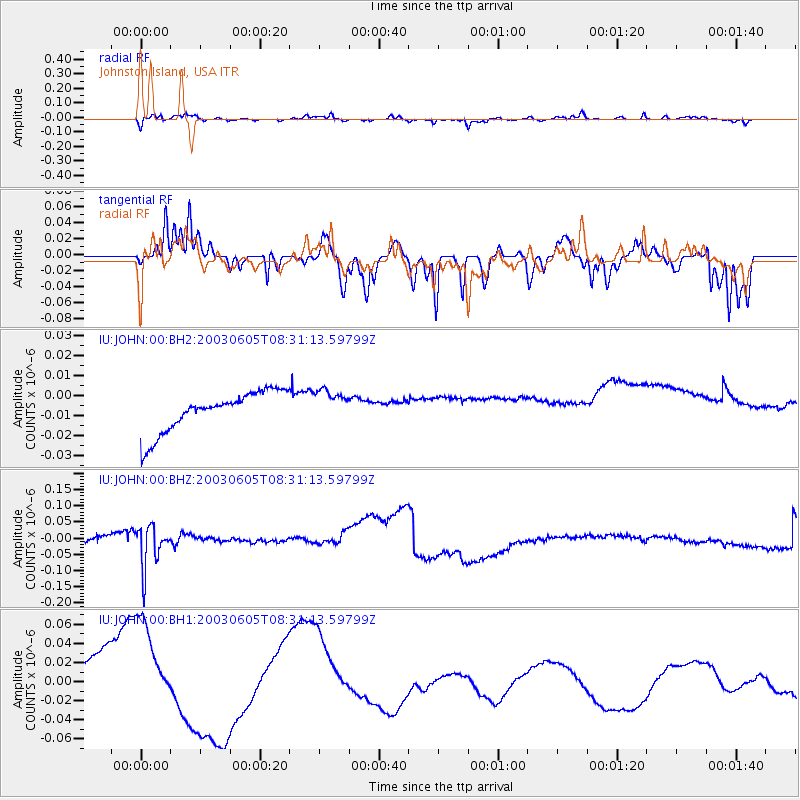
JOHN Johnston Island, USA - Earthquake Result Viewer
*The percent match for this event was below the threshold and hence no stack was calculated.
| Earthquake location: |
Kermadec Islands, New Zealand |
| Earthquake latitude/longitude: |
-30.6/-178.8 |
| Earthquake time(UTC): |
2003/06/05 (156) 08:23:17 GMT |
| Earthquake Depth: |
115 km |
| Earthquake Magnitude: |
5.8 MW, 5.5 MB, 5.7 MW |
| Earthquake Catalog/Contributor: |
NEIC PDE/NEIC PDE-M |
|
| Network: |
IU Global Seismograph Network (GSN - IRIS/USGS) |
| Station: |
JOHN Johnston Island, USA |
| Lat/Lon: |
16.73 N/169.53 W |
| Elevation: |
2.0 m |
|
| Distance: |
47.9 deg |
| Az: |
12.01 deg |
| Baz: |
190.79 deg |
| Ray Param: |
$rayparam |
*The percent match for this event was below the threshold and hence was not used in the summary stack. |
|
| Radial Match: |
29.561249 % |
| Radial Bump: |
265 |
| Transverse Match: |
15.549498 % |
| Transverse Bump: |
182 |
| SOD ConfigId: |
590571 |
| Insert Time: |
2013-09-25 02:16:24.782 +0000 |
| GWidth: |
2.5 |
| Max Bumps: |
400 |
| Tol: |
0.001 |
|
Signal To Noise
| Channel | StoN | STA | LTA |
| IU:JOHN:00:BHZ:20030605T08:31:13.59799Z | 1.3004802 | 6.793572E-8 | 5.2238946E-8 |
| IU:JOHN:00:BH1:20030605T08:31:13.59799Z | 2.133283 | 6.4204755E-8 | 3.009669E-8 |
| IU:JOHN:00:BH2:20030605T08:31:13.59799Z | 0.8353841 | 8.355675E-9 | 1.0002196E-8 |
| Arrivals |
| Ps | |
| PpPs | |
| PsPs/PpSs | |


