You are here: Home > Network List > IU - Global Seismograph Network (GSN - IRIS/USGS) Stations List
> Station JOHN Johnston Island, USA > Earthquake Result Viewer
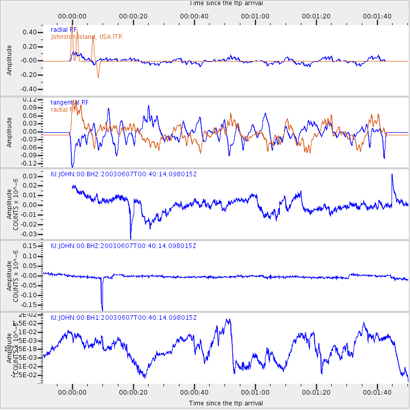
JOHN Johnston Island, USA - Earthquake Result Viewer
*The percent match for this event was below the threshold and hence no stack was calculated.
| Earthquake location: |
New Britain Region, P.N.G. |
| Earthquake latitude/longitude: |
-5.1/152.5 |
| Earthquake time(UTC): |
2003/06/07 (158) 00:32:45 GMT |
| Earthquake Depth: |
33 km |
| Earthquake Magnitude: |
6.0 MB, 6.8 MS, 6.6 MW, 6.5 MW |
| Earthquake Catalog/Contributor: |
WHDF/NEIC |
|
| Network: |
IU Global Seismograph Network (GSN - IRIS/USGS) |
| Station: |
JOHN Johnston Island, USA |
| Lat/Lon: |
16.73 N/169.53 W |
| Elevation: |
2.0 m |
|
| Distance: |
43.3 deg |
| Az: |
59.182 deg |
| Baz: |
243.225 deg |
| Ray Param: |
$rayparam |
*The percent match for this event was below the threshold and hence was not used in the summary stack. |
|
| Radial Match: |
62.456406 % |
| Radial Bump: |
400 |
| Transverse Match: |
81.9084 % |
| Transverse Bump: |
400 |
| SOD ConfigId: |
590571 |
| Insert Time: |
2013-09-25 02:17:12.953 +0000 |
| GWidth: |
2.5 |
| Max Bumps: |
400 |
| Tol: |
0.001 |
|
Signal To Noise
| Channel | StoN | STA | LTA |
| IU:JOHN:00:BHZ:20030607T00:40:14.098015Z | 0.27804103 | 1.0662467E-8 | 3.8348535E-8 |
| IU:JOHN:00:BH1:20030607T00:40:14.098015Z | 3.1250815 | 1.3776862E-8 | 4.4084807E-9 |
| IU:JOHN:00:BH2:20030607T00:40:14.098015Z | 1.0930669 | 1.0279177E-8 | 9.403977E-9 |
| Arrivals |
| Ps | |
| PpPs | |
| PsPs/PpSs | |


