You are here: Home > Network List > IU - Global Seismograph Network (GSN - IRIS/USGS) Stations List
> Station JOHN Johnston Island, USA > Earthquake Result Viewer
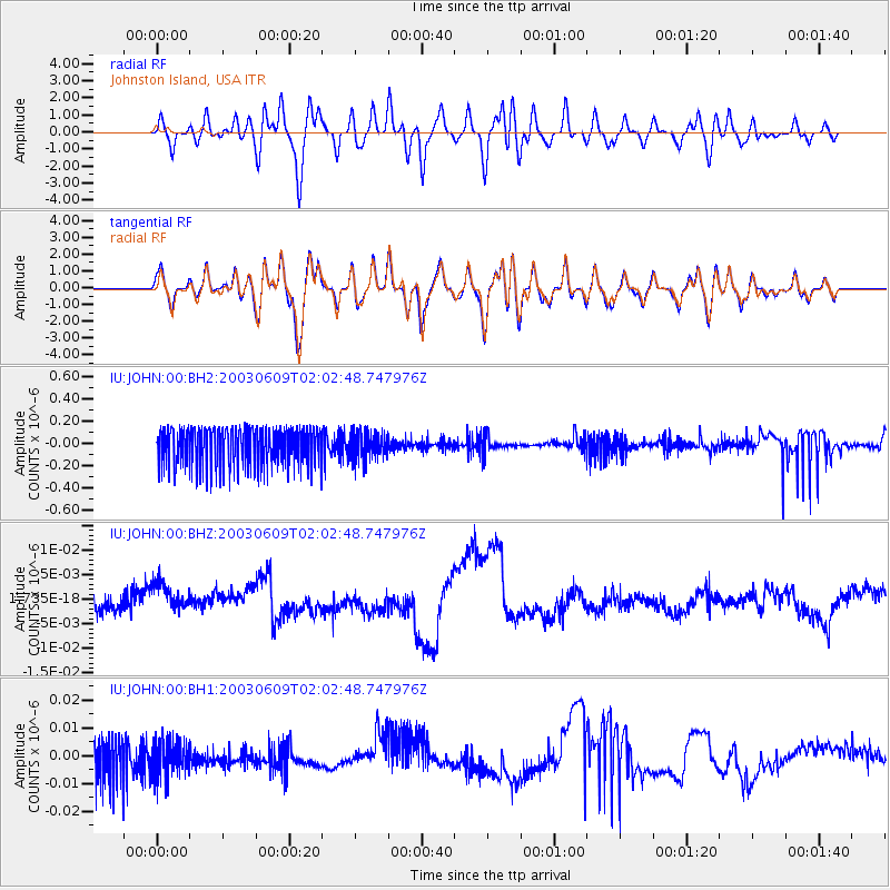
JOHN Johnston Island, USA - Earthquake Result Viewer
*The percent match for this event was below the threshold and hence no stack was calculated.
| Earthquake location: |
Taiwan Region |
| Earthquake latitude/longitude: |
24.4/122.0 |
| Earthquake time(UTC): |
2003/06/09 (160) 01:52:51 GMT |
| Earthquake Depth: |
48 km |
| Earthquake Magnitude: |
5.5 MS, 5.3 MB, 5.8 MW, 5.7 MW |
| Earthquake Catalog/Contributor: |
WHDF/NEIC |
|
| Network: |
IU Global Seismograph Network (GSN - IRIS/USGS) |
| Station: |
JOHN Johnston Island, USA |
| Lat/Lon: |
16.73 N/169.53 W |
| Elevation: |
2.0 m |
|
| Distance: |
64.0 deg |
| Az: |
82.571 deg |
| Baz: |
289.365 deg |
| Ray Param: |
$rayparam |
*The percent match for this event was below the threshold and hence was not used in the summary stack. |
|
| Radial Match: |
64.04435 % |
| Radial Bump: |
400 |
| Transverse Match: |
63.364887 % |
| Transverse Bump: |
400 |
| SOD ConfigId: |
590571 |
| Insert Time: |
2013-09-25 02:18:24.986 +0000 |
| GWidth: |
2.5 |
| Max Bumps: |
400 |
| Tol: |
0.001 |
|
Signal To Noise
| Channel | StoN | STA | LTA |
| IU:JOHN:00:BHZ:20030609T02:02:48.747976Z | 1.6283726 | 2.9935068E-9 | 1.8383426E-9 |
| IU:JOHN:00:BH1:20030609T02:02:48.747976Z | 0.66658294 | 6.463977E-9 | 9.6971835E-9 |
| IU:JOHN:00:BH2:20030609T02:02:48.747976Z | 0.6845157 | 1.2028173E-7 | 1.7571799E-7 |
| Arrivals |
| Ps | |
| PpPs | |
| PsPs/PpSs | |


