You are here: Home > Network List > IU - Global Seismograph Network (GSN - IRIS/USGS) Stations List
> Station RSSD Black Hills, South Dakota, USA > Earthquake Result Viewer
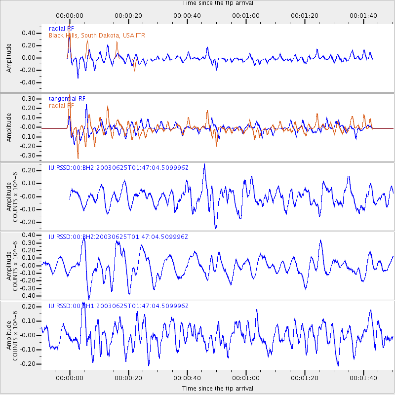
RSSD Black Hills, South Dakota, USA - Earthquake Result Viewer
*The percent match for this event was below the threshold and hence no stack was calculated.
| Earthquake location: |
Northern Mid-Atlantic Ridge |
| Earthquake latitude/longitude: |
28.8/-43.6 |
| Earthquake time(UTC): |
2003/06/25 (176) 01:38:42 GMT |
| Earthquake Depth: |
10 km |
| Earthquake Magnitude: |
5.1 MB, 5.5 MS, 5.7 MW, 5.5 MW |
| Earthquake Catalog/Contributor: |
WHDF/NEIC |
|
| Network: |
IU Global Seismograph Network (GSN - IRIS/USGS) |
| Station: |
RSSD Black Hills, South Dakota, USA |
| Lat/Lon: |
44.12 N/104.04 W |
| Elevation: |
2060 m |
|
| Distance: |
49.9 deg |
| Az: |
304.982 deg |
| Baz: |
86.631 deg |
| Ray Param: |
$rayparam |
*The percent match for this event was below the threshold and hence was not used in the summary stack. |
|
| Radial Match: |
69.90395 % |
| Radial Bump: |
400 |
| Transverse Match: |
72.03911 % |
| Transverse Bump: |
396 |
| SOD ConfigId: |
590571 |
| Insert Time: |
2013-09-25 02:25:57.199 +0000 |
| GWidth: |
2.5 |
| Max Bumps: |
400 |
| Tol: |
0.001 |
|
Signal To Noise
| Channel | StoN | STA | LTA |
| IU:RSSD:00:BHZ:20030625T01:47:04.509996Z | 2.6343818 | 1.4472312E-7 | 5.4936276E-8 |
| IU:RSSD:00:BH1:20030625T01:47:04.509996Z | 1.3527905 | 9.3687184E-8 | 6.925476E-8 |
| IU:RSSD:00:BH2:20030625T01:47:04.509996Z | 0.7949299 | 4.5338542E-8 | 5.7034637E-8 |
| Arrivals |
| Ps | |
| PpPs | |
| PsPs/PpSs | |


