You are here: Home > Network List > IU - Global Seismograph Network (GSN - IRIS/USGS) Stations List
> Station JOHN Johnston Island, USA > Earthquake Result Viewer
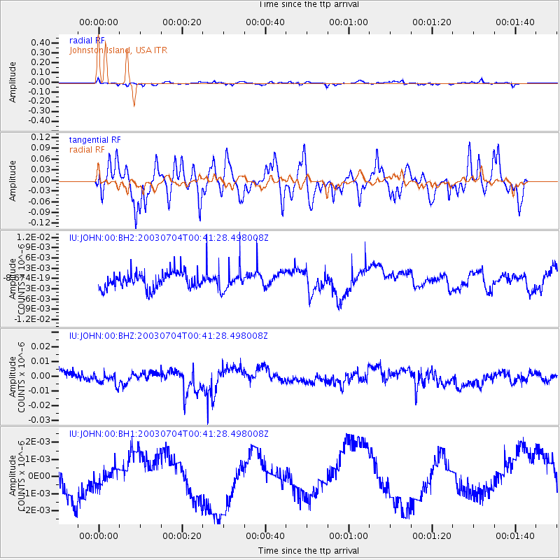
JOHN Johnston Island, USA - Earthquake Result Viewer
*The percent match for this event was below the threshold and hence no stack was calculated.
| Earthquake location: |
New Britain Region, P.N.G. |
| Earthquake latitude/longitude: |
-5.5/151.7 |
| Earthquake time(UTC): |
2003/07/04 (185) 00:33:50 GMT |
| Earthquake Depth: |
10 km |
| Earthquake Magnitude: |
5.4 MB, 5.9 MS, 6.0 MW, 5.9 MW |
| Earthquake Catalog/Contributor: |
WHDF/NEIC |
|
| Network: |
IU Global Seismograph Network (GSN - IRIS/USGS) |
| Station: |
JOHN Johnston Island, USA |
| Lat/Lon: |
16.73 N/169.53 W |
| Elevation: |
2.0 m |
|
| Distance: |
44.2 deg |
| Az: |
59.35 deg |
| Baz: |
243.355 deg |
| Ray Param: |
$rayparam |
*The percent match for this event was below the threshold and hence was not used in the summary stack. |
|
| Radial Match: |
53.46815 % |
| Radial Bump: |
357 |
| Transverse Match: |
47.344296 % |
| Transverse Bump: |
400 |
| SOD ConfigId: |
590571 |
| Insert Time: |
2013-09-25 02:30:45.686 +0000 |
| GWidth: |
2.5 |
| Max Bumps: |
400 |
| Tol: |
0.001 |
|
Signal To Noise
| Channel | StoN | STA | LTA |
| IU:JOHN:00:BHZ:20030704T00:41:28.498008Z | 1.2415546 | 5.768972E-9 | 4.646571E-9 |
| IU:JOHN:00:BH1:20030704T00:41:28.498008Z | 0.52909684 | 4.485207E-10 | 8.4771007E-10 |
| IU:JOHN:00:BH2:20030704T00:41:28.498008Z | 1.3658575 | 3.1123113E-9 | 2.2786502E-9 |
| Arrivals |
| Ps | |
| PpPs | |
| PsPs/PpSs | |


