You are here: Home > Network List > IU - Global Seismograph Network (GSN - IRIS/USGS) Stations List
> Station JOHN Johnston Island, USA > Earthquake Result Viewer
JOHN Johnston Island, USA - Earthquake Result Viewer

| Earthquake location: |
Svalbard Region |
| Earthquake latitude/longitude: |
76.4/23.3 |
| Earthquake time(UTC): |
2003/07/04 (185) 07:16:44 GMT |
| Earthquake Depth: |
10 km |
| Earthquake Magnitude: |
5.7 MB, 5.1 MS, 5.5 MW, 5.4 MW |
| Earthquake Catalog/Contributor: |
WHDF/NEIC |
|
| Network: |
IU Global Seismograph Network (GSN - IRIS/USGS) |
| Station: |
JOHN Johnston Island, USA |
| Lat/Lon: |
16.73 N/169.53 W |
| Elevation: |
2.0 m |
|
| Distance: |
86.8 deg |
| Az: |
12.287 deg |
| Baz: |
356.981 deg |
| Ray Param: |
0.043813698 |
| Estimated Moho Depth: |
45.25 km |
| Estimated Crust Vp/Vs: |
1.85 |
| Assumed Crust Vp: |
4.24 km/s |
| Estimated Crust Vs: |
2.298 km/s |
| Estimated Crust Poisson's Ratio: |
0.29 |
|
| Radial Match: |
92.73951 % |
| Radial Bump: |
232 |
| Transverse Match: |
91.93322 % |
| Transverse Bump: |
236 |
| SOD ConfigId: |
590571 |
| Insert Time: |
2013-09-25 02:31:21.844 +0000 |
| GWidth: |
2.5 |
| Max Bumps: |
400 |
| Tol: |
0.001 |
|
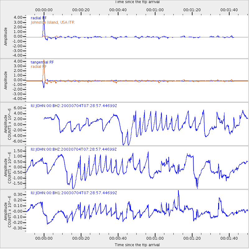
Signal To Noise
| Channel | StoN | STA | LTA |
| IU:JOHN:00:BHZ:20030704T07:28:57.44699Z | 0.8477696 | 4.32939E-7 | 5.1068E-7 |
| IU:JOHN:00:BH1:20030704T07:28:57.44699Z | 3.7516165 | 1.861477E-7 | 4.9618E-8 |
| IU:JOHN:00:BH2:20030704T07:28:57.44699Z | 0.8281503 | 1.5280235E-6 | 1.8451041E-6 |
| Arrivals |
| Ps | 9.1 SECOND |
| PpPs | 30 SECOND |
| PsPs/PpSs | 39 SECOND |


