You are here: Home > Network List > IU - Global Seismograph Network (GSN - IRIS/USGS) Stations List
> Station JOHN Johnston Island, USA > Earthquake Result Viewer
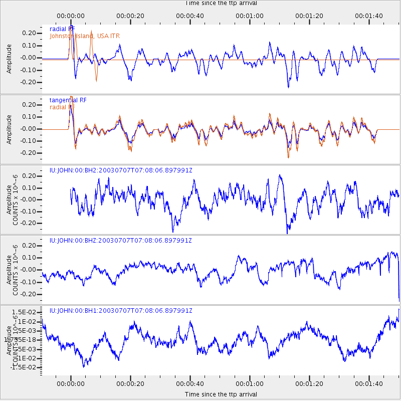
JOHN Johnston Island, USA - Earthquake Result Viewer
*The percent match for this event was below the threshold and hence no stack was calculated.
| Earthquake location: |
Xizang |
| Earthquake latitude/longitude: |
34.6/89.5 |
| Earthquake time(UTC): |
2003/07/07 (188) 06:55:43 GMT |
| Earthquake Depth: |
18 km |
| Earthquake Magnitude: |
5.5 MW, 5.7 MS, 5.8 MW |
| Earthquake Catalog/Contributor: |
NEIC PDE/NEIC PDE-M |
|
| Network: |
IU Global Seismograph Network (GSN - IRIS/USGS) |
| Station: |
JOHN Johnston Island, USA |
| Lat/Lon: |
16.73 N/169.53 W |
| Elevation: |
2.0 m |
|
| Distance: |
89.4 deg |
| Az: |
70.162 deg |
| Baz: |
305.928 deg |
| Ray Param: |
$rayparam |
*The percent match for this event was below the threshold and hence was not used in the summary stack. |
|
| Radial Match: |
37.419067 % |
| Radial Bump: |
376 |
| Transverse Match: |
35.961052 % |
| Transverse Bump: |
342 |
| SOD ConfigId: |
590571 |
| Insert Time: |
2013-09-25 02:32:44.702 +0000 |
| GWidth: |
2.5 |
| Max Bumps: |
400 |
| Tol: |
0.001 |
|
Signal To Noise
| Channel | StoN | STA | LTA |
| IU:JOHN:00:BHZ:20030707T07:08:06.897991Z | 0.6352937 | 9.506753E-8 | 1.4964343E-7 |
| IU:JOHN:00:BH1:20030707T07:08:06.897991Z | 1.9864026 | 1.2119729E-8 | 6.1013457E-9 |
| IU:JOHN:00:BH2:20030707T07:08:06.897991Z | 1.6059061 | 1.1893594E-7 | 7.4061575E-8 |
| Arrivals |
| Ps | |
| PpPs | |
| PsPs/PpSs | |


