You are here: Home > Network List > IU - Global Seismograph Network (GSN - IRIS/USGS) Stations List
> Station JOHN Johnston Island, USA > Earthquake Result Viewer
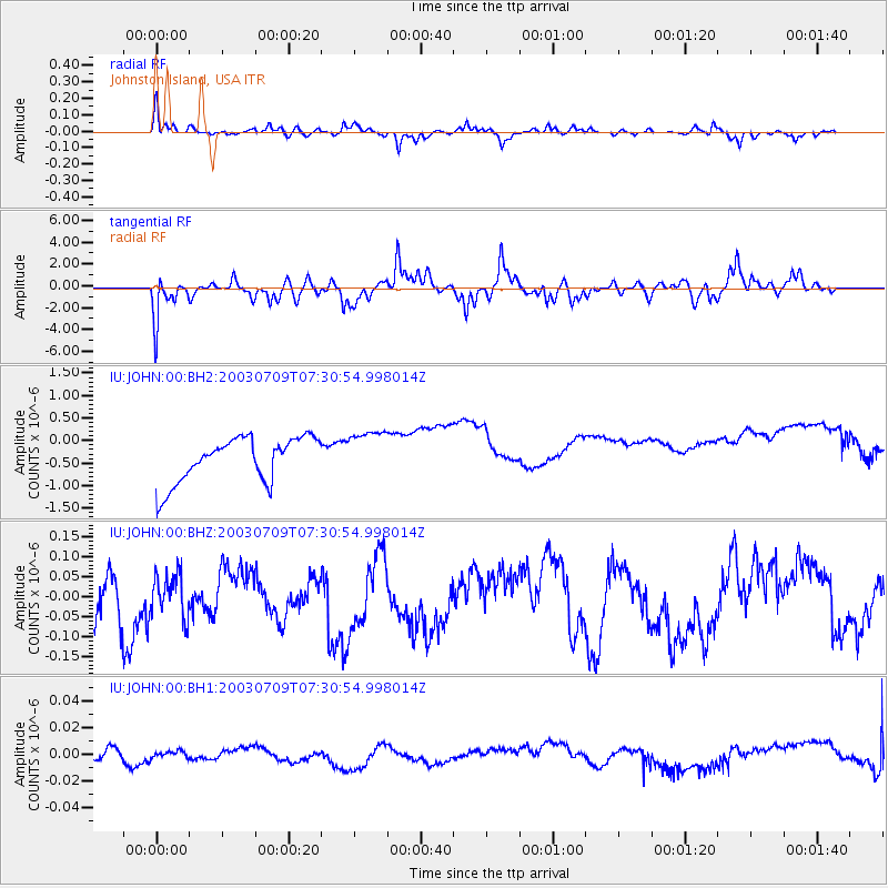
JOHN Johnston Island, USA - Earthquake Result Viewer
*The percent match for this event was below the threshold and hence no stack was calculated.
| Earthquake location: |
Near N Coast Of New Guinea, P.N.G. |
| Earthquake latitude/longitude: |
-4.9/145.2 |
| Earthquake time(UTC): |
2003/07/09 (190) 07:22:39 GMT |
| Earthquake Depth: |
53 km |
| Earthquake Magnitude: |
5.4 MB, 5.0 MS, 5.6 MW, 5.5 MW |
| Earthquake Catalog/Contributor: |
WHDF/NEIC |
|
| Network: |
IU Global Seismograph Network (GSN - IRIS/USGS) |
| Station: |
JOHN Johnston Island, USA |
| Lat/Lon: |
16.73 N/169.53 W |
| Elevation: |
2.0 m |
|
| Distance: |
49.6 deg |
| Az: |
63.267 deg |
| Baz: |
248.231 deg |
| Ray Param: |
$rayparam |
*The percent match for this event was below the threshold and hence was not used in the summary stack. |
|
| Radial Match: |
73.8646 % |
| Radial Bump: |
391 |
| Transverse Match: |
69.40567 % |
| Transverse Bump: |
400 |
| SOD ConfigId: |
590571 |
| Insert Time: |
2013-09-25 02:33:34.951 +0000 |
| GWidth: |
2.5 |
| Max Bumps: |
400 |
| Tol: |
0.001 |
|
Signal To Noise
| Channel | StoN | STA | LTA |
| IU:JOHN:00:BHZ:20030709T07:30:54.998014Z | 0.7542864 | 5.7906906E-8 | 7.677045E-8 |
| IU:JOHN:00:BH1:20030709T07:30:54.998014Z | 0.39847252 | 2.564456E-9 | 6.4357164E-9 |
| IU:JOHN:00:BH2:20030709T07:30:54.998014Z | 1.081594 | 5.37353E-7 | 4.9681586E-7 |
| Arrivals |
| Ps | |
| PpPs | |
| PsPs/PpSs | |


