You are here: Home > Network List > IU - Global Seismograph Network (GSN - IRIS/USGS) Stations List
> Station MBWA Marble Bar, Western Australia > Earthquake Result Viewer
MBWA Marble Bar, Western Australia - Earthquake Result Viewer
| Earthquake location: |
New Britain Region, P.N.G. |
| Earthquake latitude/longitude: |
-5.5/148.9 |
| Earthquake time(UTC): |
2003/07/21 (202) 13:53:58 GMT |
| Earthquake Depth: |
190 km |
| Earthquake Magnitude: |
6.2 MB, 6.4 MW, 6.3 MW |
| Earthquake Catalog/Contributor: |
WHDF/NEIC |
|
| Network: |
IU Global Seismograph Network (GSN - IRIS/USGS) |
| Station: |
MBWA Marble Bar, Western Australia |
| Lat/Lon: |
21.16 S/119.73 E |
| Elevation: |
190 m |
|
| Distance: |
32.2 deg |
| Az: |
238.363 deg |
| Baz: |
65.234 deg |
| Ray Param: |
0.07815007 |
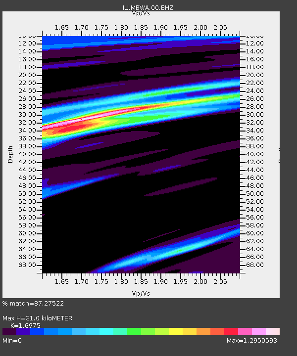
| Estimated Moho Depth: |
31.0 km |
| Estimated Crust Vp/Vs: |
1.70 |
| Assumed Crust Vp: |
6.464 km/s |
| Estimated Crust Vs: |
3.808 km/s |
| Estimated Crust Poisson's Ratio: |
0.23 |
|
| Radial Match: |
87.27522 % |
| Radial Bump: |
345 |
| Transverse Match: |
59.47026 % |
| Transverse Bump: |
400 |
| SOD ConfigId: |
590571 |
| Insert Time: |
2013-09-25 02:39:13.386 +0000 |
| GWidth: |
2.5 |
| Max Bumps: |
400 |
| Tol: |
0.001 |
|

Signal To Noise
| Channel | StoN | STA | LTA |
| IU:MBWA:00:BHZ:20030721T13:59:38.660013Z | 8.538484 | 3.5142357E-6 | 4.1157608E-7 |
| IU:MBWA:00:BH1:20030721T13:59:38.660013Z | 3.966705 | 2.034747E-6 | 5.1295643E-7 |
| IU:MBWA:00:BH2:20030721T13:59:38.660013Z | 2.127221 | 8.84341E-7 | 4.1572594E-7 |
| Arrivals |
| Ps | 3.6 SECOND |
| PpPs | 12 SECOND |
| PsPs/PpSs | 16 SECOND |


