You are here: Home > Network List > IU - Global Seismograph Network (GSN - IRIS/USGS) Stations List
> Station POHA Pohakuloa, Hawaii, USA > Earthquake Result Viewer
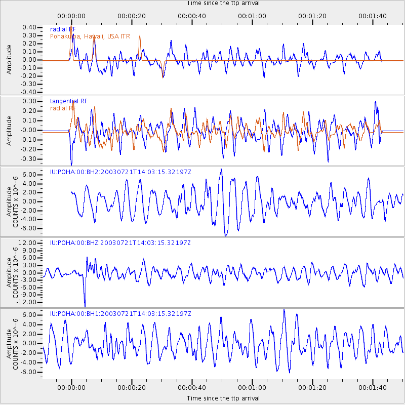
POHA Pohakuloa, Hawaii, USA - Earthquake Result Viewer
*The percent match for this event was below the threshold and hence no stack was calculated.
| Earthquake location: |
New Britain Region, P.N.G. |
| Earthquake latitude/longitude: |
-5.5/148.9 |
| Earthquake time(UTC): |
2003/07/21 (202) 13:53:58 GMT |
| Earthquake Depth: |
190 km |
| Earthquake Magnitude: |
6.2 MB, 6.4 MW, 6.3 MW |
| Earthquake Catalog/Contributor: |
WHDF/NEIC |
|
| Network: |
IU Global Seismograph Network (GSN - IRIS/USGS) |
| Station: |
POHA Pohakuloa, Hawaii, USA |
| Lat/Lon: |
19.76 N/155.53 W |
| Elevation: |
1967 m |
|
| Distance: |
60.2 deg |
| Az: |
63.65 deg |
| Baz: |
251.287 deg |
| Ray Param: |
$rayparam |
*The percent match for this event was below the threshold and hence was not used in the summary stack. |
|
| Radial Match: |
51.478798 % |
| Radial Bump: |
393 |
| Transverse Match: |
51.713768 % |
| Transverse Bump: |
400 |
| SOD ConfigId: |
590571 |
| Insert Time: |
2013-09-25 02:39:18.209 +0000 |
| GWidth: |
2.5 |
| Max Bumps: |
400 |
| Tol: |
0.001 |
|
Signal To Noise
| Channel | StoN | STA | LTA |
| IU:POHA:00:BHZ:20030721T14:03:15.32197Z | 3.4680817 | 3.979566E-6 | 1.1474833E-6 |
| IU:POHA:00:BH1:20030721T14:03:15.32197Z | 0.7421715 | 1.9244962E-6 | 2.5930613E-6 |
| IU:POHA:00:BH2:20030721T14:03:15.32197Z | 0.72726536 | 1.8802826E-6 | 2.585415E-6 |
| Arrivals |
| Ps | |
| PpPs | |
| PsPs/PpSs | |


