You are here: Home > Network List > IU - Global Seismograph Network (GSN - IRIS/USGS) Stations List
> Station RSSD Black Hills, South Dakota, USA > Earthquake Result Viewer
RSSD Black Hills, South Dakota, USA - Earthquake Result Viewer
| Earthquake location: |
Eastern Honshu, Japan |
| Earthquake latitude/longitude: |
38.4/141.0 |
| Earthquake time(UTC): |
2003/07/25 (206) 22:13:29 GMT |
| Earthquake Depth: |
6.0 km |
| Earthquake Magnitude: |
6.0 MB, 5.8 MS, 6.1 MW, 5.9 MW |
| Earthquake Catalog/Contributor: |
WHDF/NEIC |
|
| Network: |
IU Global Seismograph Network (GSN - IRIS/USGS) |
| Station: |
RSSD Black Hills, South Dakota, USA |
| Lat/Lon: |
44.12 N/104.04 W |
| Elevation: |
2060 m |
|
| Distance: |
79.0 deg |
| Az: |
41.688 deg |
| Baz: |
313.496 deg |
| Ray Param: |
0.04925482 |
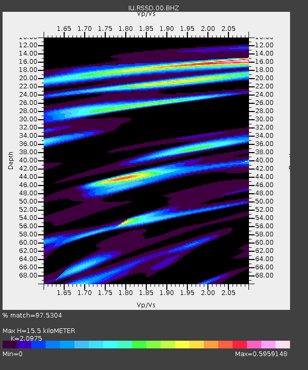
| Estimated Moho Depth: |
15.5 km |
| Estimated Crust Vp/Vs: |
2.10 |
| Assumed Crust Vp: |
6.242 km/s |
| Estimated Crust Vs: |
2.976 km/s |
| Estimated Crust Poisson's Ratio: |
0.35 |
|
| Radial Match: |
97.5304 % |
| Radial Bump: |
298 |
| Transverse Match: |
88.520546 % |
| Transverse Bump: |
400 |
| SOD ConfigId: |
590571 |
| Insert Time: |
2013-09-25 02:43:31.214 +0000 |
| GWidth: |
2.5 |
| Max Bumps: |
400 |
| Tol: |
0.001 |
|
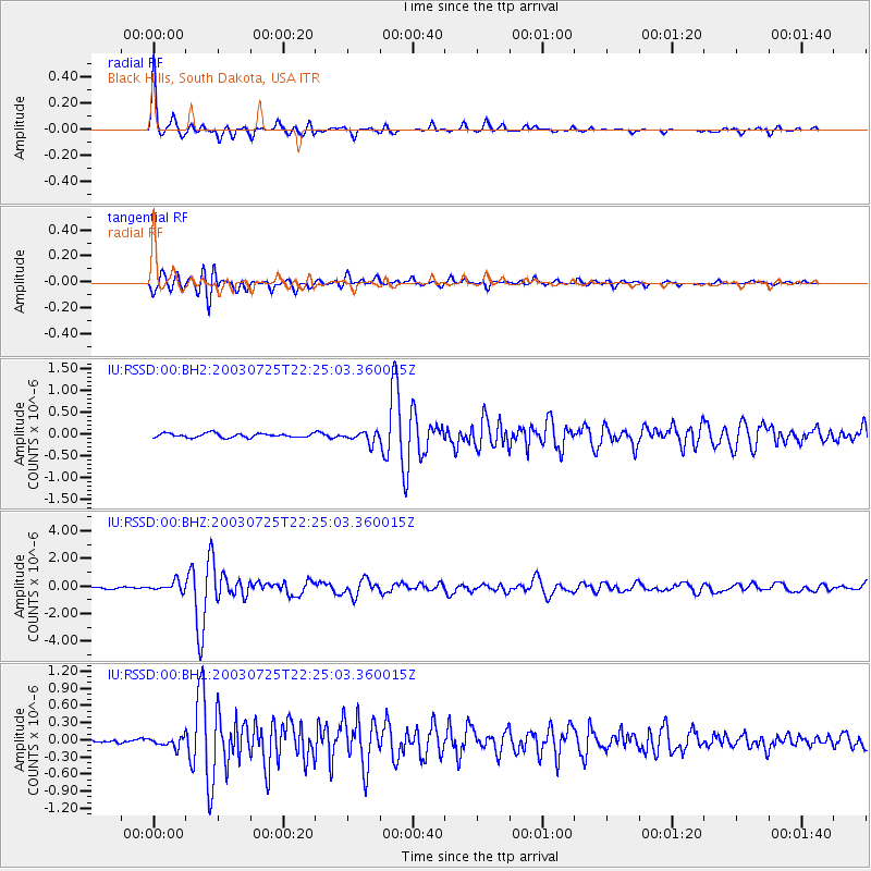
Signal To Noise
| Channel | StoN | STA | LTA |
| IU:RSSD:00:BHZ:20030725T22:25:03.360015Z | 7.1838284 | 3.454679E-7 | 4.8089667E-8 |
| IU:RSSD:00:BH1:20030725T22:25:03.360015Z | 1.6719445 | 8.416484E-8 | 5.0339494E-8 |
| IU:RSSD:00:BH2:20030725T22:25:03.360015Z | 2.665842 | 1.2326655E-7 | 4.623925E-8 |
| Arrivals |
| Ps | 2.8 SECOND |
| PpPs | 7.5 SECOND |
| PsPs/PpSs | 10 SECOND |


