You are here: Home > Network List > IU - Global Seismograph Network (GSN - IRIS/USGS) Stations List
> Station RSSD Black Hills, South Dakota, USA > Earthquake Result Viewer
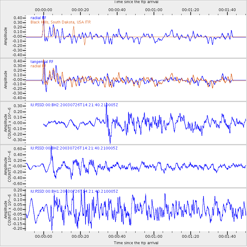
RSSD Black Hills, South Dakota, USA - Earthquake Result Viewer
*The percent match for this event was below the threshold and hence no stack was calculated.
| Earthquake location: |
Central Chile |
| Earthquake latitude/longitude: |
-28.2/-70.9 |
| Earthquake time(UTC): |
2003/07/26 (207) 14:10:16 GMT |
| Earthquake Depth: |
36 km |
| Earthquake Magnitude: |
5.5 MW |
| Earthquake Catalog/Contributor: |
NEIC PDE/NEIC PDE-M |
|
| Network: |
IU Global Seismograph Network (GSN - IRIS/USGS) |
| Station: |
RSSD Black Hills, South Dakota, USA |
| Lat/Lon: |
44.12 N/104.04 W |
| Elevation: |
2060 m |
|
| Distance: |
78.1 deg |
| Az: |
336.299 deg |
| Baz: |
150.487 deg |
| Ray Param: |
$rayparam |
*The percent match for this event was below the threshold and hence was not used in the summary stack. |
|
| Radial Match: |
71.91551 % |
| Radial Bump: |
400 |
| Transverse Match: |
67.55961 % |
| Transverse Bump: |
400 |
| SOD ConfigId: |
590571 |
| Insert Time: |
2013-09-25 02:45:00.853 +0000 |
| GWidth: |
2.5 |
| Max Bumps: |
400 |
| Tol: |
0.001 |
|
Signal To Noise
| Channel | StoN | STA | LTA |
| IU:RSSD:00:BHZ:20030726T14:21:40.210005Z | 4.2491517 | 2.2337545E-7 | 5.2569423E-8 |
| IU:RSSD:00:BH1:20030726T14:21:40.210005Z | 1.4402968 | 7.546388E-8 | 5.239467E-8 |
| IU:RSSD:00:BH2:20030726T14:21:40.210005Z | 2.8798075 | 1.01592775E-7 | 3.527763E-8 |
| Arrivals |
| Ps | |
| PpPs | |
| PsPs/PpSs | |


