You are here: Home > Network List > IU - Global Seismograph Network (GSN - IRIS/USGS) Stations List
> Station RSSD Black Hills, South Dakota, USA > Earthquake Result Viewer
RSSD Black Hills, South Dakota, USA - Earthquake Result Viewer
| Earthquake location: |
Fiji Islands Region |
| Earthquake latitude/longitude: |
-21.1/-176.6 |
| Earthquake time(UTC): |
2003/07/27 (208) 02:04:11 GMT |
| Earthquake Depth: |
213 km |
| Earthquake Magnitude: |
5.9 MB, 6.6 MW, 6.6 MW |
| Earthquake Catalog/Contributor: |
WHDF/NEIC |
|
| Network: |
IU Global Seismograph Network (GSN - IRIS/USGS) |
| Station: |
RSSD Black Hills, South Dakota, USA |
| Lat/Lon: |
44.12 N/104.04 W |
| Elevation: |
2060 m |
|
| Distance: |
92.7 deg |
| Az: |
43.456 deg |
| Baz: |
243.108 deg |
| Ray Param: |
0.04128585 |
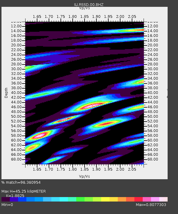
| Estimated Moho Depth: |
45.25 km |
| Estimated Crust Vp/Vs: |
1.88 |
| Assumed Crust Vp: |
6.242 km/s |
| Estimated Crust Vs: |
3.316 km/s |
| Estimated Crust Poisson's Ratio: |
0.30 |
|
| Radial Match: |
96.360954 % |
| Radial Bump: |
359 |
| Transverse Match: |
91.95764 % |
| Transverse Bump: |
400 |
| SOD ConfigId: |
590571 |
| Insert Time: |
2013-09-25 02:46:14.176 +0000 |
| GWidth: |
2.5 |
| Max Bumps: |
400 |
| Tol: |
0.001 |
|
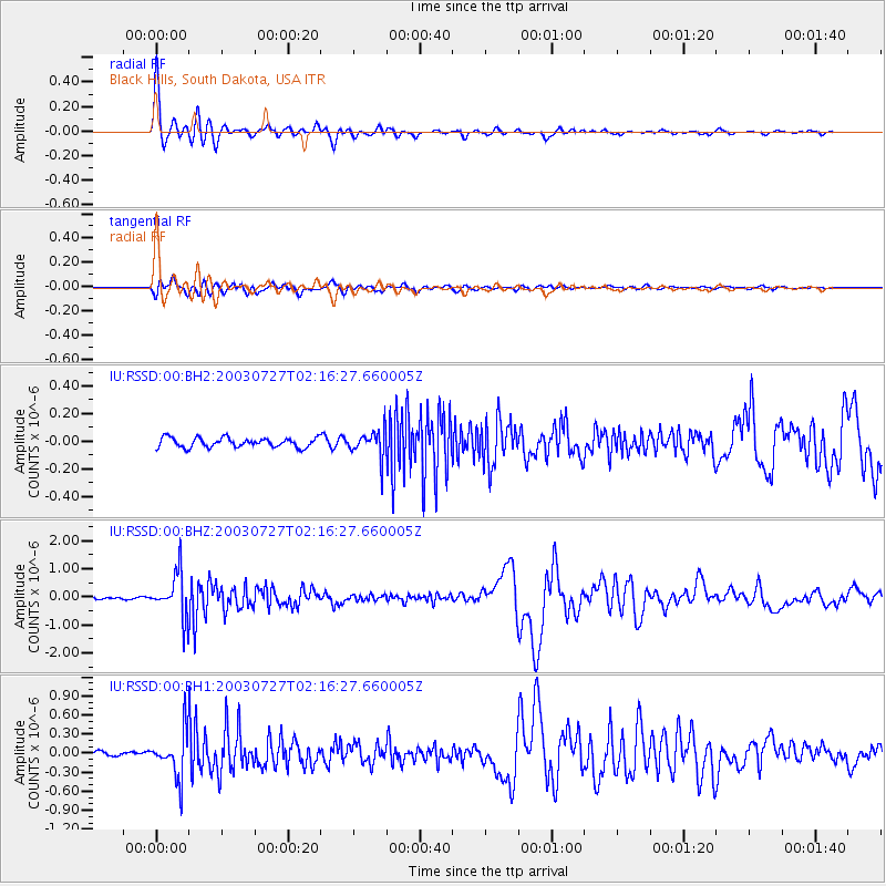
Signal To Noise
| Channel | StoN | STA | LTA |
| IU:RSSD:00:BHZ:20030727T02:16:27.660005Z | 10.416624 | 7.652146E-7 | 7.34609E-8 |
| IU:RSSD:00:BH1:20030727T02:16:27.660005Z | 8.084263 | 3.6006048E-7 | 4.4538442E-8 |
| IU:RSSD:00:BH2:20030727T02:16:27.660005Z | 2.9093108 | 1.0045668E-7 | 3.4529375E-8 |
| Arrivals |
| Ps | 6.5 SECOND |
| PpPs | 21 SECOND |
| PsPs/PpSs | 27 SECOND |


