You are here: Home > Network List > IU - Global Seismograph Network (GSN - IRIS/USGS) Stations List
> Station RSSD Black Hills, South Dakota, USA > Earthquake Result Viewer
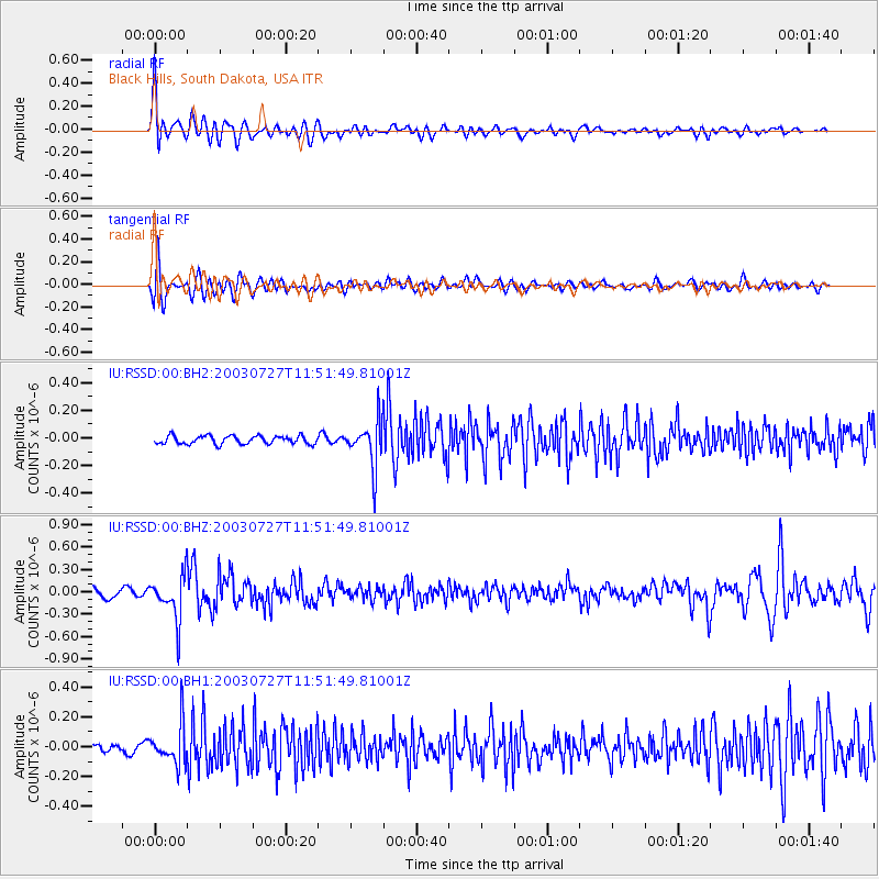
RSSD Black Hills, South Dakota, USA - Earthquake Result Viewer
*The percent match for this event was below the threshold and hence no stack was calculated.
| Earthquake location: |
Southern Bolivia |
| Earthquake latitude/longitude: |
-20.1/-65.2 |
| Earthquake time(UTC): |
2003/07/27 (208) 11:41:27 GMT |
| Earthquake Depth: |
345 km |
| Earthquake Magnitude: |
5.9 MB, 6.0 MW, 6.0 MW |
| Earthquake Catalog/Contributor: |
WHDF/NEIC |
|
| Network: |
IU Global Seismograph Network (GSN - IRIS/USGS) |
| Station: |
RSSD Black Hills, South Dakota, USA |
| Lat/Lon: |
44.12 N/104.04 W |
| Elevation: |
2060 m |
|
| Distance: |
73.2 deg |
| Az: |
331.834 deg |
| Baz: |
141.988 deg |
| Ray Param: |
$rayparam |
*The percent match for this event was below the threshold and hence was not used in the summary stack. |
|
| Radial Match: |
77.81647 % |
| Radial Bump: |
400 |
| Transverse Match: |
68.98118 % |
| Transverse Bump: |
400 |
| SOD ConfigId: |
590571 |
| Insert Time: |
2013-09-25 02:47:17.140 +0000 |
| GWidth: |
2.5 |
| Max Bumps: |
400 |
| Tol: |
0.001 |
|
Signal To Noise
| Channel | StoN | STA | LTA |
| IU:RSSD:00:BHZ:20030727T11:51:49.81001Z | 5.188269 | 2.9179512E-7 | 5.6241323E-8 |
| IU:RSSD:00:BH1:20030727T11:51:49.81001Z | 3.4801428 | 1.3212234E-7 | 3.7964632E-8 |
| IU:RSSD:00:BH2:20030727T11:51:49.81001Z | 5.3444552 | 1.5861966E-7 | 2.9679292E-8 |
| Arrivals |
| Ps | |
| PpPs | |
| PsPs/PpSs | |


