You are here: Home > Network List > IU - Global Seismograph Network (GSN - IRIS/USGS) Stations List
> Station JOHN Johnston Island, USA > Earthquake Result Viewer
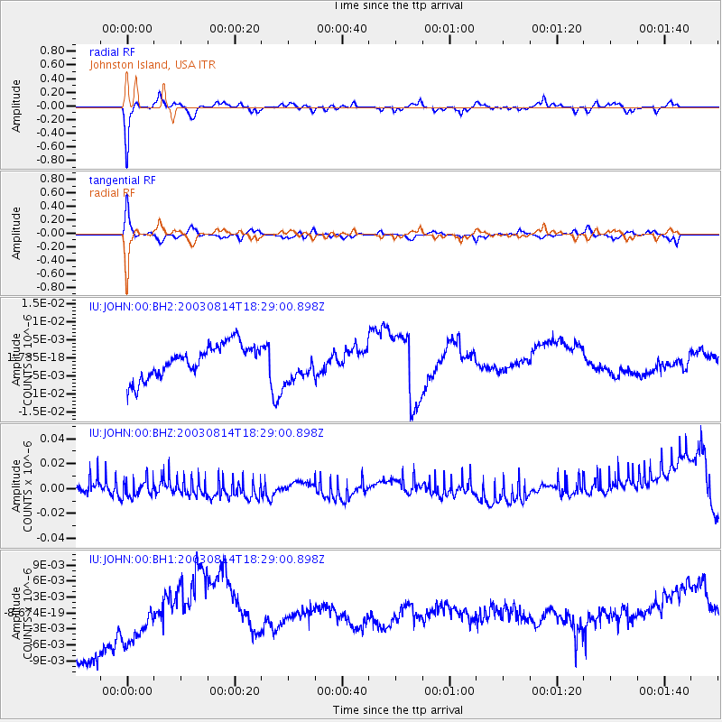
JOHN Johnston Island, USA - Earthquake Result Viewer
*The percent match for this event was below the threshold and hence no stack was calculated.
| Earthquake location: |
Fiji Islands Region |
| Earthquake latitude/longitude: |
-19.9/-178.0 |
| Earthquake time(UTC): |
2003/08/14 (226) 18:23:06 GMT |
| Earthquake Depth: |
563 km |
| Earthquake Magnitude: |
5.9 MW |
| Earthquake Catalog/Contributor: |
NEIC PDE/NEIC PDE-M |
|
| Network: |
IU Global Seismograph Network (GSN - IRIS/USGS) |
| Station: |
JOHN Johnston Island, USA |
| Lat/Lon: |
16.73 N/169.53 W |
| Elevation: |
2.0 m |
|
| Distance: |
37.3 deg |
| Az: |
13.431 deg |
| Baz: |
193.186 deg |
| Ray Param: |
$rayparam |
*The percent match for this event was below the threshold and hence was not used in the summary stack. |
|
| Radial Match: |
81.58839 % |
| Radial Bump: |
400 |
| Transverse Match: |
81.80056 % |
| Transverse Bump: |
391 |
| SOD ConfigId: |
590571 |
| Insert Time: |
2013-09-25 02:54:50.191 +0000 |
| GWidth: |
2.5 |
| Max Bumps: |
400 |
| Tol: |
0.001 |
|
Signal To Noise
| Channel | StoN | STA | LTA |
| IU:JOHN:00:BHZ:20030814T18:29:00.898Z | 1.3221254 | 6.796926E-9 | 5.1409086E-9 |
| IU:JOHN:00:BH1:20030814T18:29:00.898Z | 0.7201699 | 6.2596905E-9 | 8.691964E-9 |
| IU:JOHN:00:BH2:20030814T18:29:00.898Z | 1.0576677 | 4.7662683E-9 | 4.5063944E-9 |
| Arrivals |
| Ps | |
| PpPs | |
| PsPs/PpSs | |


