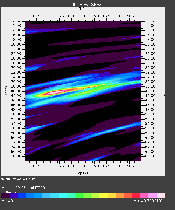
TRQA Tornquist, Argentina - Earthquake Result Viewer

Earthquake location: South Island, New Zealand
Earthquake latitude/longitude: -45.1/167.1
Earthquake time(UTC): 2003/08/21 (233) 12:12:49 GMT
Earthquake Depth: 28 km
Earthquake Magnitude: 7.1 MW, 6.6 MB, 7.2 MW, 7.5 MS
Earthquake Catalog/Contributor: NEIC PDE/NEIC PDE-M
Network: IU Global Seismograph Network (GSN - IRIS/USGS)
Station: TRQA Tornquist, Argentina
Lat/Lon: 38.06 S/61.98 W
Elevation: 540 m
Distance: 86.1 deg
Az: 143.256 deg
Baz: 212.459 deg
Ray Param: 0.04423984
Estimated Moho Depth: 40.25 km
Estimated Crust Vp/Vs: 1.74
Assumed Crust Vp: 6.472 km/s
Estimated Crust Vs: 3.73 km/s
Estimated Crust Poisson's Ratio: 0.25
Radial Match: 94.86359 %
Radial Bump: 400
Transverse Match: 82.19859 %
Transverse Bump: 400
SOD ConfigId: 590571
Insert Time: 2013-09-25 02:57:09.599 +0000
GWidth: 2.5
Max Bumps: 400
Tol: 0.001

Signal To Noise

ChannelStoNSTALTA
IU:TRQA:00:BHZ:20030821T12:24:56.81002Z2.07768581.7455658E-68.40149E-7
IU:TRQA:00:BH1:20030821T12:24:56.81002Z0.456982371.488573E-73.2573968E-7
IU:TRQA:00:BH2:20030821T12:24:56.81002Z1.11619076.750633E-76.047921E-7
Arrivals
Ps4.7 SECOND
PpPs17 SECOND
PsPs/PpSs21 SECOND