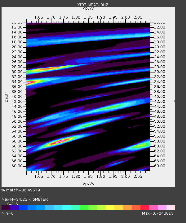
MPAT MPAT - Earthquake Result Viewer

Earthquake location: Jujuy Province, Argentina
Earthquake latitude/longitude: -23.9/-66.6
Earthquake time(UTC): 2014/09/24 (267) 11:16:12 GMT
Earthquake Depth: 189 km
Earthquake Magnitude: 6.2 MWP, 6.2 MWB, 6.2 MWC
Earthquake Catalog/Contributor: NEIC PDE/NEIC COMCAT
Network: YT POLENET
Station: MPAT MPAT
Lat/Lon: 78.03 S/155.02 W
Elevation: 540 m
Distance: 66.5 deg
Az: 193.15 deg
Baz: 93.752 deg
Ray Param: 0.05700719
Estimated Moho Depth: 34.25 km
Estimated Crust Vp/Vs: 1.60
Assumed Crust Vp: 6.43 km/s
Estimated Crust Vs: 4.019 km/s
Estimated Crust Poisson's Ratio: 0.18
Radial Match: 86.49679 %
Radial Bump: 332
Transverse Match: 80.227234 %
Transverse Bump: 400
SOD ConfigId: 3390531
Insert Time: 2019-04-14 05:04:12.224 +0000
GWidth: 2.5
Max Bumps: 400
Tol: 0.001

Signal To Noise

ChannelStoNSTALTA
YT:MPAT: :BHZ:20140924T11:26:10.50002Z13.4326241.7381935E-61.2940089E-7
YT:MPAT: :BHN:20140924T11:26:10.50002Z0.88980619.520982E-81.0700064E-7
YT:MPAT: :BHE:20140924T11:26:10.50002Z9.5269937.4452885E-77.8149405E-8
Arrivals
Ps3.3 SECOND
PpPs13 SECOND
PsPs/PpSs17 SECOND