You are here: Home > Network List > IU - Global Seismograph Network (GSN - IRIS/USGS) Stations List
> Station RSSD Black Hills, South Dakota, USA > Earthquake Result Viewer
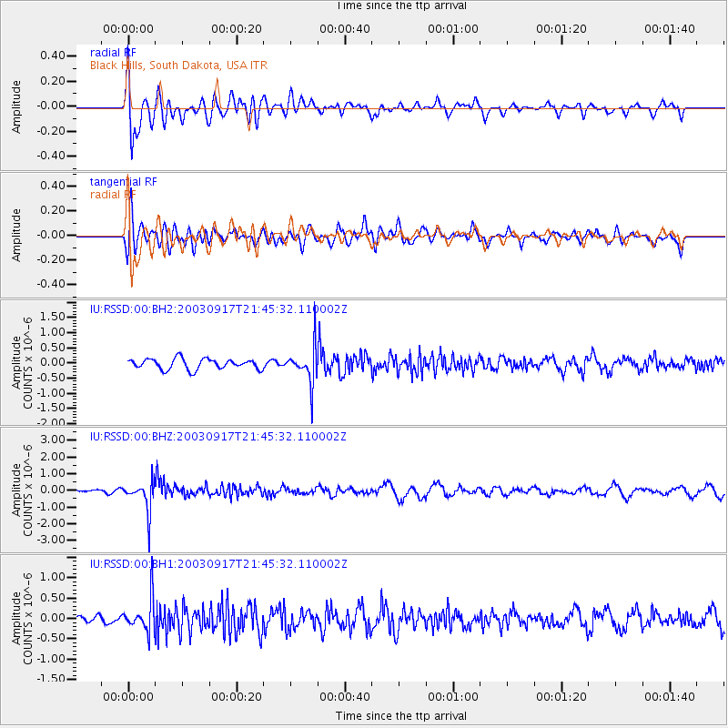
RSSD Black Hills, South Dakota, USA - Earthquake Result Viewer
*The percent match for this event was below the threshold and hence no stack was calculated.
| Earthquake location: |
Chile-Bolivia Border Region |
| Earthquake latitude/longitude: |
-21.5/-68.3 |
| Earthquake time(UTC): |
2003/09/17 (260) 21:34:47 GMT |
| Earthquake Depth: |
127 km |
| Earthquake Magnitude: |
5.9 MB, 5.8 MW, 5.7 MW |
| Earthquake Catalog/Contributor: |
WHDF/NEIC |
|
| Network: |
IU Global Seismograph Network (GSN - IRIS/USGS) |
| Station: |
RSSD Black Hills, South Dakota, USA |
| Lat/Lon: |
44.12 N/104.04 W |
| Elevation: |
2060 m |
|
| Distance: |
73.0 deg |
| Az: |
333.923 deg |
| Baz: |
145.353 deg |
| Ray Param: |
$rayparam |
*The percent match for this event was below the threshold and hence was not used in the summary stack. |
|
| Radial Match: |
76.55954 % |
| Radial Bump: |
400 |
| Transverse Match: |
52.127884 % |
| Transverse Bump: |
400 |
| SOD ConfigId: |
590571 |
| Insert Time: |
2013-09-25 03:17:21.497 +0000 |
| GWidth: |
2.5 |
| Max Bumps: |
400 |
| Tol: |
0.001 |
|
Signal To Noise
| Channel | StoN | STA | LTA |
| IU:RSSD:00:BHZ:20030917T21:45:32.110002Z | 5.5438046 | 9.1859516E-7 | 1.6569761E-7 |
| IU:RSSD:00:BH1:20030917T21:45:32.110002Z | 3.3590293 | 4.146307E-7 | 1.2343766E-7 |
| IU:RSSD:00:BH2:20030917T21:45:32.110002Z | 3.5327127 | 6.0840244E-7 | 1.7221961E-7 |
| Arrivals |
| Ps | |
| PpPs | |
| PsPs/PpSs | |


