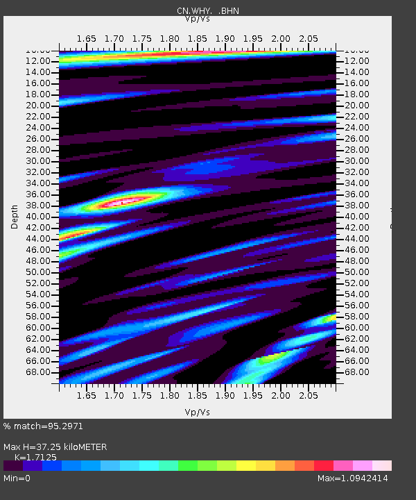
WHY Whitehorse, YT - Earthquake Result Viewer

Earthquake location: Philippine Islands Region
Earthquake latitude/longitude: 20.3/122.0
Earthquake time(UTC): 2000/07/16 (198) 03:21:45 GMT
Earthquake Depth: 33 km
Earthquake Magnitude: 6.1 MB, 6.3 MS, 6.4 MW, 6.4 MW
Earthquake Catalog/Contributor: WHDF/NEIC
Network: CN Canadian National Seismograph Network
Station: WHY Whitehorse, YT
Lat/Lon: 60.66 N/134.88 W
Elevation: 1292 m
Distance: 78.8 deg
Az: 29.282 deg
Baz: 291.179 deg
Ray Param: 0.04937592
Estimated Moho Depth: 37.25 km
Estimated Crust Vp/Vs: 1.71
Assumed Crust Vp: 6.419 km/s
Estimated Crust Vs: 3.748 km/s
Estimated Crust Poisson's Ratio: 0.24
Radial Match: 95.2971 %
Radial Bump: 400
Transverse Match: 91.06623 %
Transverse Bump: 400
SOD ConfigId: 3744
Insert Time: 2010-02-27 07:39:33.558 +0000
GWidth: 2.5
Max Bumps: 400
Tol: 0.001

Signal To Noise

ChannelStoNSTALTA
CN:WHY: :BHN:20000716T03:33:13.725007Z2.038123365.02634179.09929
CN:WHY: :BHE:20000716T03:33:13.725007Z2.283765547.9204239.91977
CN:WHY: :BHZ:20000716T03:33:13.725007Z11.1923322125.6924189.92398
Arrivals
Ps4.3 SECOND
PpPs15 SECOND
PsPs/PpSs20 SECOND