You are here: Home > Network List > IU - Global Seismograph Network (GSN - IRIS/USGS) Stations List
> Station POHA Pohakuloa, Hawaii, USA > Earthquake Result Viewer
POHA Pohakuloa, Hawaii, USA - Earthquake Result Viewer
| Earthquake location: |
Hokkaido, Japan Region |
| Earthquake latitude/longitude: |
41.8/143.9 |
| Earthquake time(UTC): |
2003/09/25 (268) 19:50:06 GMT |
| Earthquake Depth: |
27 km |
| Earthquake Magnitude: |
6.9 MB, 8.1 MS, 8.3 MW, 8.1 MW |
| Earthquake Catalog/Contributor: |
WHDF/NEIC |
|
| Network: |
IU Global Seismograph Network (GSN - IRIS/USGS) |
| Station: |
POHA Pohakuloa, Hawaii, USA |
| Lat/Lon: |
19.76 N/155.53 W |
| Elevation: |
1967 m |
|
| Distance: |
55.3 deg |
| Az: |
93.929 deg |
| Baz: |
307.645 deg |
| Ray Param: |
0.064840145 |
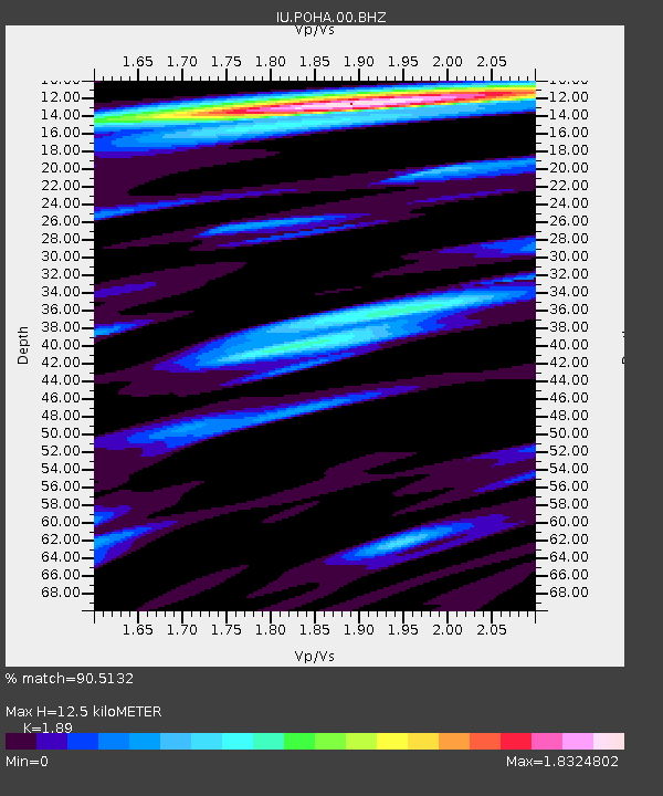
| Estimated Moho Depth: |
12.5 km |
| Estimated Crust Vp/Vs: |
1.89 |
| Assumed Crust Vp: |
5.195 km/s |
| Estimated Crust Vs: |
2.749 km/s |
| Estimated Crust Poisson's Ratio: |
0.31 |
|
| Radial Match: |
90.5132 % |
| Radial Bump: |
400 |
| Transverse Match: |
86.39847 % |
| Transverse Bump: |
400 |
| SOD ConfigId: |
590571 |
| Insert Time: |
2013-09-25 03:21:22.397 +0000 |
| GWidth: |
2.5 |
| Max Bumps: |
400 |
| Tol: |
0.001 |
|
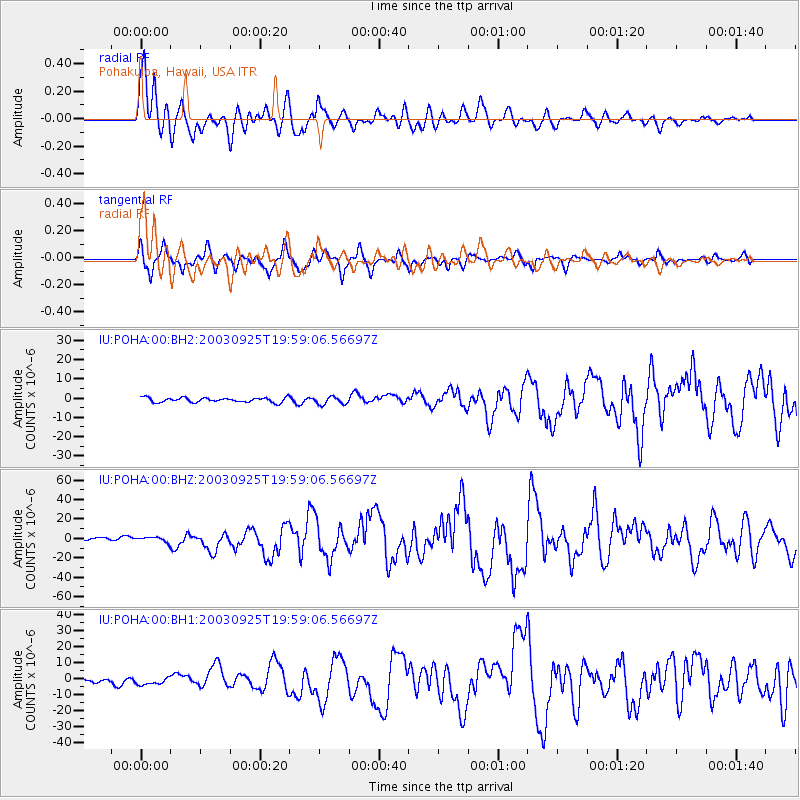
Signal To Noise
| Channel | StoN | STA | LTA |
| IU:POHA:00:BHZ:20030925T19:59:06.56697Z | 1.9597108 | 2.4843025E-6 | 1.2676883E-6 |
| IU:POHA:00:BH1:20030925T19:59:06.56697Z | 1.7775947 | 1.9820673E-6 | 1.1150277E-6 |
| IU:POHA:00:BH2:20030925T19:59:06.56697Z | 1.673478 | 1.9915308E-6 | 1.190055E-6 |
| Arrivals |
| Ps | 2.2 SECOND |
| PpPs | 6.7 SECOND |
| PsPs/PpSs | 8.9 SECOND |


