You are here: Home > Network List > IU - Global Seismograph Network (GSN - IRIS/USGS) Stations List
> Station JOHN Johnston Island, USA > Earthquake Result Viewer
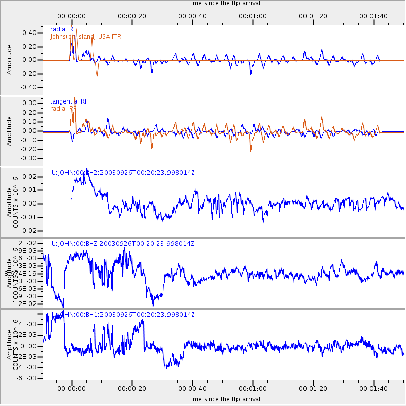
JOHN Johnston Island, USA - Earthquake Result Viewer
*The percent match for this event was below the threshold and hence no stack was calculated.
| Earthquake location: |
Tonga Islands Region |
| Earthquake latitude/longitude: |
-22.3/-175.3 |
| Earthquake time(UTC): |
2003/09/26 (269) 00:13:29 GMT |
| Earthquake Depth: |
33 km |
| Earthquake Magnitude: |
5.6 MS |
| Earthquake Catalog/Contributor: |
NEIC PDE/NEIC PDE-M |
|
| Network: |
IU Global Seismograph Network (GSN - IRIS/USGS) |
| Station: |
JOHN Johnston Island, USA |
| Lat/Lon: |
16.73 N/169.53 W |
| Elevation: |
2.0 m |
|
| Distance: |
39.2 deg |
| Az: |
8.734 deg |
| Baz: |
188.437 deg |
| Ray Param: |
$rayparam |
*The percent match for this event was below the threshold and hence was not used in the summary stack. |
|
| Radial Match: |
47.743694 % |
| Radial Bump: |
348 |
| Transverse Match: |
48.426052 % |
| Transverse Bump: |
400 |
| SOD ConfigId: |
590571 |
| Insert Time: |
2013-09-25 03:23:40.953 +0000 |
| GWidth: |
2.5 |
| Max Bumps: |
400 |
| Tol: |
0.001 |
|
Signal To Noise
| Channel | StoN | STA | LTA |
| IU:JOHN:00:BHZ:20030926T00:20:23.998014Z | 0.69995236 | 1.4014596E-8 | 2.0022215E-8 |
| IU:JOHN:00:BH1:20030926T00:20:23.998014Z | 0.4843786 | 2.900816E-9 | 5.988737E-9 |
| IU:JOHN:00:BH2:20030926T00:20:23.998014Z | 1.3802866 | 1.2935663E-8 | 9.371723E-9 |
| Arrivals |
| Ps | |
| PpPs | |
| PsPs/PpSs | |


