You are here: Home > Network List > IU - Global Seismograph Network (GSN - IRIS/USGS) Stations List
> Station RSSD Black Hills, South Dakota, USA > Earthquake Result Viewer
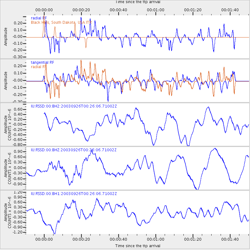
RSSD Black Hills, South Dakota, USA - Earthquake Result Viewer
*The percent match for this event was below the threshold and hence no stack was calculated.
| Earthquake location: |
Tonga Islands Region |
| Earthquake latitude/longitude: |
-22.3/-175.3 |
| Earthquake time(UTC): |
2003/09/26 (269) 00:13:29 GMT |
| Earthquake Depth: |
33 km |
| Earthquake Magnitude: |
5.6 MS |
| Earthquake Catalog/Contributor: |
NEIC PDE/NEIC PDE-M |
|
| Network: |
IU Global Seismograph Network (GSN - IRIS/USGS) |
| Station: |
RSSD Black Hills, South Dakota, USA |
| Lat/Lon: |
44.12 N/104.04 W |
| Elevation: |
2060 m |
|
| Distance: |
92.7 deg |
| Az: |
43.059 deg |
| Baz: |
241.366 deg |
| Ray Param: |
$rayparam |
*The percent match for this event was below the threshold and hence was not used in the summary stack. |
|
| Radial Match: |
65.60053 % |
| Radial Bump: |
400 |
| Transverse Match: |
50.84221 % |
| Transverse Bump: |
400 |
| SOD ConfigId: |
590571 |
| Insert Time: |
2013-09-25 03:23:44.738 +0000 |
| GWidth: |
2.5 |
| Max Bumps: |
400 |
| Tol: |
0.001 |
|
Signal To Noise
| Channel | StoN | STA | LTA |
| IU:RSSD:00:BHZ:20030926T00:26:06.71002Z | 0.6312271 | 2.079934E-7 | 3.2950643E-7 |
| IU:RSSD:00:BH1:20030926T00:26:06.71002Z | 2.4133024 | 1.0069182E-6 | 4.1723663E-7 |
| IU:RSSD:00:BH2:20030926T00:26:06.71002Z | 1.0541707 | 2.8465618E-7 | 2.7002852E-7 |
| Arrivals |
| Ps | |
| PpPs | |
| PsPs/PpSs | |


