You are here: Home > Network List > IU - Global Seismograph Network (GSN - IRIS/USGS) Stations List
> Station JOHN Johnston Island, USA > Earthquake Result Viewer
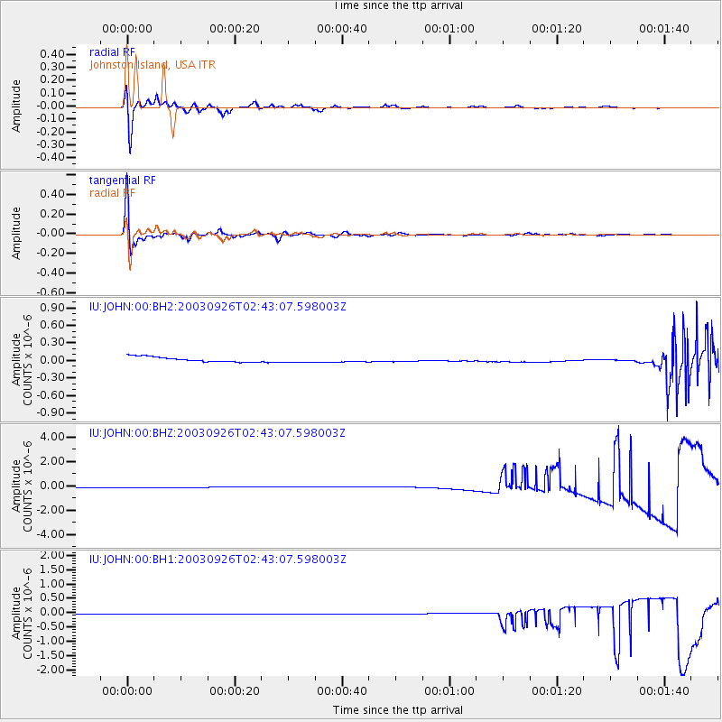
JOHN Johnston Island, USA - Earthquake Result Viewer
*The percent match for this event was below the threshold and hence no stack was calculated.
| Earthquake location: |
Hokkaido, Japan Region |
| Earthquake latitude/longitude: |
42.0/144.4 |
| Earthquake time(UTC): |
2003/09/26 (269) 02:35:13 GMT |
| Earthquake Depth: |
33 km |
| Earthquake Magnitude: |
5.6 MB, 5.5 MS |
| Earthquake Catalog/Contributor: |
NEIC PDE/NEIC PDE-M |
|
| Network: |
IU Global Seismograph Network (GSN - IRIS/USGS) |
| Station: |
JOHN Johnston Island, USA |
| Lat/Lon: |
16.73 N/169.53 W |
| Elevation: |
2.0 m |
|
| Distance: |
46.6 deg |
| Az: |
108.463 deg |
| Baz: |
312.446 deg |
| Ray Param: |
$rayparam |
*The percent match for this event was below the threshold and hence was not used in the summary stack. |
|
| Radial Match: |
90.26086 % |
| Radial Bump: |
400 |
| Transverse Match: |
95.48473 % |
| Transverse Bump: |
347 |
| SOD ConfigId: |
590571 |
| Insert Time: |
2013-09-25 03:24:09.004 +0000 |
| GWidth: |
2.5 |
| Max Bumps: |
400 |
| Tol: |
0.001 |
|
Signal To Noise
| Channel | StoN | STA | LTA |
| IU:JOHN:00:BHZ:20030926T02:43:07.598003Z | 0.92134005 | 2.6185086E-7 | 2.8420652E-7 |
| IU:JOHN:00:BH1:20030926T02:43:07.598003Z | 0.7027676 | 8.743963E-9 | 1.2442182E-8 |
| IU:JOHN:00:BH2:20030926T02:43:07.598003Z | 1.0533592 | 4.632018E-8 | 4.397378E-8 |
| Arrivals |
| Ps | |
| PpPs | |
| PsPs/PpSs | |


