You are here: Home > Network List > IU - Global Seismograph Network (GSN - IRIS/USGS) Stations List
> Station RSSD Black Hills, South Dakota, USA > Earthquake Result Viewer
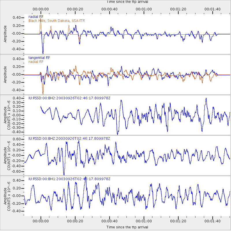
RSSD Black Hills, South Dakota, USA - Earthquake Result Viewer
*The percent match for this event was below the threshold and hence no stack was calculated.
| Earthquake location: |
Hokkaido, Japan Region |
| Earthquake latitude/longitude: |
42.0/144.4 |
| Earthquake time(UTC): |
2003/09/26 (269) 02:35:13 GMT |
| Earthquake Depth: |
33 km |
| Earthquake Magnitude: |
5.6 MB, 5.5 MS |
| Earthquake Catalog/Contributor: |
NEIC PDE/NEIC PDE-M |
|
| Network: |
IU Global Seismograph Network (GSN - IRIS/USGS) |
| Station: |
RSSD Black Hills, South Dakota, USA |
| Lat/Lon: |
44.12 N/104.04 W |
| Elevation: |
2060 m |
|
| Distance: |
74.6 deg |
| Az: |
44.025 deg |
| Baz: |
314.003 deg |
| Ray Param: |
$rayparam |
*The percent match for this event was below the threshold and hence was not used in the summary stack. |
|
| Radial Match: |
63.31826 % |
| Radial Bump: |
400 |
| Transverse Match: |
47.886253 % |
| Transverse Bump: |
395 |
| SOD ConfigId: |
590571 |
| Insert Time: |
2013-09-25 03:24:15.361 +0000 |
| GWidth: |
2.5 |
| Max Bumps: |
400 |
| Tol: |
0.001 |
|
Signal To Noise
| Channel | StoN | STA | LTA |
| IU:RSSD:00:BHZ:20030926T02:46:17.809978Z | 1.4101577 | 2.0786854E-7 | 1.47408E-7 |
| IU:RSSD:00:BH1:20030926T02:46:17.809978Z | 0.784066 | 1.3165527E-7 | 1.679135E-7 |
| IU:RSSD:00:BH2:20030926T02:46:17.809978Z | 1.4014918 | 1.419838E-7 | 1.0130905E-7 |
| Arrivals |
| Ps | |
| PpPs | |
| PsPs/PpSs | |


