You are here: Home > Network List > IU - Global Seismograph Network (GSN - IRIS/USGS) Stations List
> Station RSSD Black Hills, South Dakota, USA > Earthquake Result Viewer
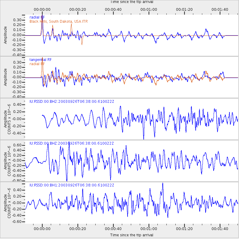
RSSD Black Hills, South Dakota, USA - Earthquake Result Viewer
*The percent match for this event was below the threshold and hence no stack was calculated.
| Earthquake location: |
Hokkaido, Japan Region |
| Earthquake latitude/longitude: |
42.2/144.7 |
| Earthquake time(UTC): |
2003/09/26 (269) 06:26:57 GMT |
| Earthquake Depth: |
33 km |
| Earthquake Magnitude: |
5.9 MB, 5.6 MS, 5.9 MW |
| Earthquake Catalog/Contributor: |
WHDF/NEIC |
|
| Network: |
IU Global Seismograph Network (GSN - IRIS/USGS) |
| Station: |
RSSD Black Hills, South Dakota, USA |
| Lat/Lon: |
44.12 N/104.04 W |
| Elevation: |
2060 m |
|
| Distance: |
74.4 deg |
| Az: |
44.172 deg |
| Baz: |
313.995 deg |
| Ray Param: |
$rayparam |
*The percent match for this event was below the threshold and hence was not used in the summary stack. |
|
| Radial Match: |
60.399975 % |
| Radial Bump: |
400 |
| Transverse Match: |
53.57202 % |
| Transverse Bump: |
400 |
| SOD ConfigId: |
590571 |
| Insert Time: |
2013-09-25 03:24:50.115 +0000 |
| GWidth: |
2.5 |
| Max Bumps: |
400 |
| Tol: |
0.001 |
|
Signal To Noise
| Channel | StoN | STA | LTA |
| IU:RSSD:00:BHZ:20030926T06:38:00.610022Z | 1.640285 | 2.8982208E-7 | 1.7669007E-7 |
| IU:RSSD:00:BH1:20030926T06:38:00.610022Z | 1.0917557 | 1.4014725E-7 | 1.2836868E-7 |
| IU:RSSD:00:BH2:20030926T06:38:00.610022Z | 1.5481671 | 1.6529145E-7 | 1.067659E-7 |
| Arrivals |
| Ps | |
| PpPs | |
| PsPs/PpSs | |


