You are here: Home > Network List > CN - Canadian National Seismograph Network Stations List
> Station WHY Whitehorse, YT > Earthquake Result Viewer
WHY Whitehorse, YT - Earthquake Result Viewer
| Earthquake location: |
Sulawesi, Indonesia |
| Earthquake latitude/longitude: |
-1.1/123.6 |
| Earthquake time(UTC): |
2000/05/04 (125) 04:21:16 GMT |
| Earthquake Depth: |
26 km |
| Earthquake Magnitude: |
6.7 MB, 7.5 MS, 7.6 MW, 7.5 ME |
| Earthquake Catalog/Contributor: |
WHDF/NEIC |
|
| Network: |
CN Canadian National Seismograph Network |
| Station: |
WHY Whitehorse, YT |
| Lat/Lon: |
60.66 N/134.88 W |
| Elevation: |
1292 m |
|
| Distance: |
96.6 deg |
| Az: |
29.063 deg |
| Baz: |
279.546 deg |
| Ray Param: |
0.040450793 |
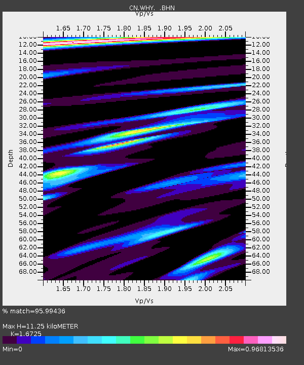
| Estimated Moho Depth: |
11.25 km |
| Estimated Crust Vp/Vs: |
1.67 |
| Assumed Crust Vp: |
6.419 km/s |
| Estimated Crust Vs: |
3.838 km/s |
| Estimated Crust Poisson's Ratio: |
0.22 |
|
| Radial Match: |
95.99436 % |
| Radial Bump: |
310 |
| Transverse Match: |
87.05519 % |
| Transverse Bump: |
400 |
| SOD ConfigId: |
3744 |
| Insert Time: |
2010-02-27 07:39:53.706 +0000 |
| GWidth: |
2.5 |
| Max Bumps: |
400 |
| Tol: |
0.001 |
|
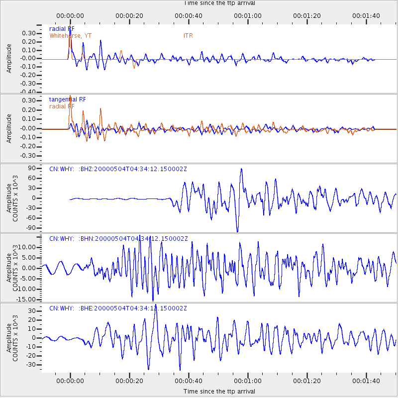
Signal To Noise
| Channel | StoN | STA | LTA |
| CN:WHY: :BHN:20000504T04:34:12.150002Z | 1.2868371 | 1736.3372 | 1349.306 |
| CN:WHY: :BHE:20000504T04:34:12.150002Z | 1.5180639 | 1372.5544 | 904.148 |
| CN:WHY: :BHZ:20000504T04:34:12.150002Z | 4.2264853 | 4615.5815 | 1092.0614 |
| Arrivals |
| Ps | 1.2 SECOND |
| PpPs | 4.6 SECOND |
| PsPs/PpSs | 5.8 SECOND |


