You are here: Home > Network List > IU - Global Seismograph Network (GSN - IRIS/USGS) Stations List
> Station JOHN Johnston Island, USA > Earthquake Result Viewer
JOHN Johnston Island, USA - Earthquake Result Viewer

| Earthquake location: |
South Island, New Zealand |
| Earthquake latitude/longitude: |
-45.5/167.0 |
| Earthquake time(UTC): |
2003/09/30 (273) 19:37:50 GMT |
| Earthquake Depth: |
10 km |
| Earthquake Magnitude: |
5.6 MW, 5.6 MW |
| Earthquake Catalog/Contributor: |
NEIC PDE/NEIC PDE-M |
|
| Network: |
IU Global Seismograph Network (GSN - IRIS/USGS) |
| Station: |
JOHN Johnston Island, USA |
| Lat/Lon: |
16.73 N/169.53 W |
| Elevation: |
2.0 m |
|
| Distance: |
65.5 deg |
| Az: |
24.754 deg |
| Baz: |
197.904 deg |
| Ray Param: |
0.058249407 |
| Estimated Moho Depth: |
36.5 km |
| Estimated Crust Vp/Vs: |
1.73 |
| Assumed Crust Vp: |
4.24 km/s |
| Estimated Crust Vs: |
2.451 km/s |
| Estimated Crust Poisson's Ratio: |
0.25 |
|
| Radial Match: |
83.60119 % |
| Radial Bump: |
258 |
| Transverse Match: |
83.73289 % |
| Transverse Bump: |
264 |
| SOD ConfigId: |
590571 |
| Insert Time: |
2013-09-25 03:32:04.193 +0000 |
| GWidth: |
2.5 |
| Max Bumps: |
400 |
| Tol: |
0.001 |
|
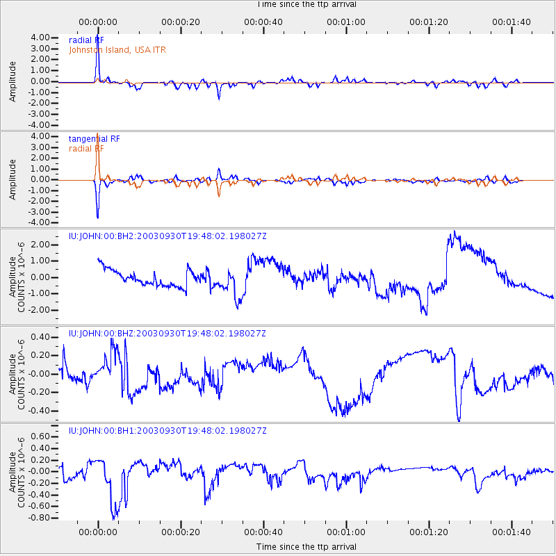
Signal To Noise
| Channel | StoN | STA | LTA |
| IU:JOHN:00:BHZ:20030930T19:48:02.198027Z | 2.2329943 | 1.9902468E-7 | 8.912906E-8 |
| IU:JOHN:00:BH1:20030930T19:48:02.198027Z | 6.572326 | 4.360562E-7 | 6.634732E-8 |
| IU:JOHN:00:BH2:20030930T19:48:02.198027Z | 1.8635551 | 9.064094E-7 | 4.8638725E-7 |
| Arrivals |
| Ps | 6.4 SECOND |
| PpPs | 23 SECOND |
| PsPs/PpSs | 29 SECOND |


