You are here: Home > Network List > IU - Global Seismograph Network (GSN - IRIS/USGS) Stations List
> Station JOHN Johnston Island, USA > Earthquake Result Viewer
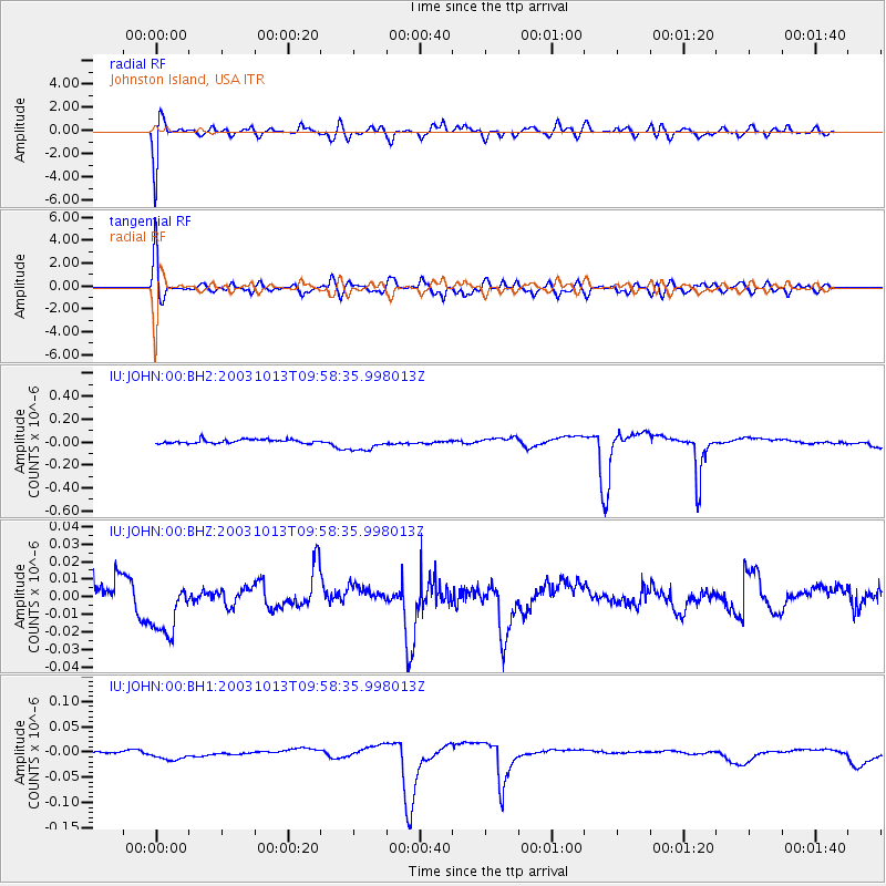
JOHN Johnston Island, USA - Earthquake Result Viewer
*The percent match for this event was below the threshold and hence no stack was calculated.
| Earthquake location: |
Fiji Islands Region |
| Earthquake latitude/longitude: |
-15.9/-178.4 |
| Earthquake time(UTC): |
2003/10/13 (286) 09:52:26 GMT |
| Earthquake Depth: |
10 km |
| Earthquake Magnitude: |
5.9 MW, 5.5 MB, 5.8 MS, 6.0 MW |
| Earthquake Catalog/Contributor: |
NEIC PDE/NEIC PDE-M |
|
| Network: |
IU Global Seismograph Network (GSN - IRIS/USGS) |
| Station: |
JOHN Johnston Island, USA |
| Lat/Lon: |
16.73 N/169.53 W |
| Elevation: |
2.0 m |
|
| Distance: |
33.6 deg |
| Az: |
15.521 deg |
| Baz: |
195.585 deg |
| Ray Param: |
$rayparam |
*The percent match for this event was below the threshold and hence was not used in the summary stack. |
|
| Radial Match: |
63.289864 % |
| Radial Bump: |
400 |
| Transverse Match: |
61.357273 % |
| Transverse Bump: |
400 |
| SOD ConfigId: |
590571 |
| Insert Time: |
2013-09-25 03:39:55.999 +0000 |
| GWidth: |
2.5 |
| Max Bumps: |
400 |
| Tol: |
0.001 |
|
Signal To Noise
| Channel | StoN | STA | LTA |
| IU:JOHN:00:BHZ:20031013T09:58:35.998013Z | 2.5623224 | 1.7412567E-8 | 6.7956196E-9 |
| IU:JOHN:00:BH1:20031013T09:58:35.998013Z | 4.101231 | 1.0521729E-8 | 2.5655051E-9 |
| IU:JOHN:00:BH2:20031013T09:58:35.998013Z | 3.8364356 | 6.312179E-8 | 1.6453239E-8 |
| Arrivals |
| Ps | |
| PpPs | |
| PsPs/PpSs | |


