You are here: Home > Network List > II - Global Seismograph Network (GSN - IRIS/IDA) Stations List
> Station PALK Pallekele, Sri Lanka > Earthquake Result Viewer
PALK Pallekele, Sri Lanka - Earthquake Result Viewer
| Earthquake location: |
Solomon Islands |
| Earthquake latitude/longitude: |
-5.5/154.2 |
| Earthquake time(UTC): |
2003/10/17 (290) 10:19:06 GMT |
| Earthquake Depth: |
133 km |
| Earthquake Magnitude: |
6.4 MW, 6.2 MB, 6.4 MW |
| Earthquake Catalog/Contributor: |
NEIC PDE/NEIC PDE-M |
|
| Network: |
II Global Seismograph Network (GSN - IRIS/IDA) |
| Station: |
PALK Pallekele, Sri Lanka |
| Lat/Lon: |
7.27 N/80.70 E |
| Elevation: |
460 m |
|
| Distance: |
74.4 deg |
| Az: |
279.078 deg |
| Baz: |
97.735 deg |
| Ray Param: |
0.05204315 |
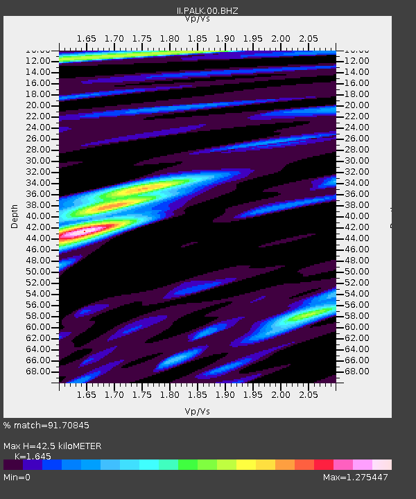
| Estimated Moho Depth: |
42.5 km |
| Estimated Crust Vp/Vs: |
1.64 |
| Assumed Crust Vp: |
6.545 km/s |
| Estimated Crust Vs: |
3.979 km/s |
| Estimated Crust Poisson's Ratio: |
0.21 |
|
| Radial Match: |
91.70845 % |
| Radial Bump: |
400 |
| Transverse Match: |
80.73818 % |
| Transverse Bump: |
400 |
| SOD ConfigId: |
590571 |
| Insert Time: |
2013-09-25 03:41:04.981 +0000 |
| GWidth: |
2.5 |
| Max Bumps: |
400 |
| Tol: |
0.001 |
|
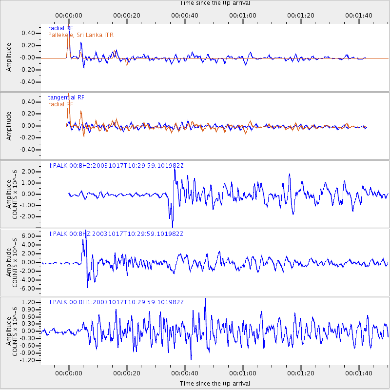
Signal To Noise
| Channel | StoN | STA | LTA |
| II:PALK:00:BHZ:20031017T10:29:59.101982Z | 9.586258 | 1.2761773E-6 | 1.331257E-7 |
| II:PALK:00:BH1:20031017T10:29:59.101982Z | 1.1699346 | 9.90494E-8 | 8.466234E-8 |
| II:PALK:00:BH2:20031017T10:29:59.101982Z | 3.8928678 | 5.1095554E-7 | 1.3125428E-7 |
| Arrivals |
| Ps | 4.3 SECOND |
| PpPs | 17 SECOND |
| PsPs/PpSs | 21 SECOND |


