You are here: Home > Network List > IU - Global Seismograph Network (GSN - IRIS/USGS) Stations List
> Station POHA Pohakuloa, Hawaii, USA > Earthquake Result Viewer
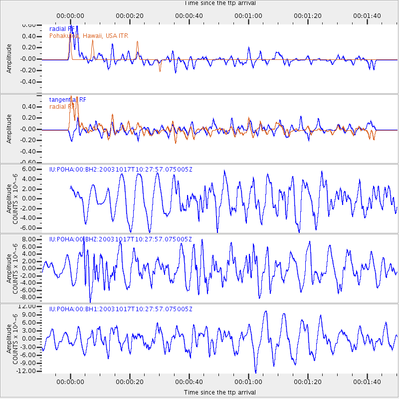
POHA Pohakuloa, Hawaii, USA - Earthquake Result Viewer
*The percent match for this event was below the threshold and hence no stack was calculated.
| Earthquake location: |
Solomon Islands |
| Earthquake latitude/longitude: |
-5.5/154.2 |
| Earthquake time(UTC): |
2003/10/17 (290) 10:19:06 GMT |
| Earthquake Depth: |
133 km |
| Earthquake Magnitude: |
6.4 MW, 6.2 MB, 6.4 MW |
| Earthquake Catalog/Contributor: |
NEIC PDE/NEIC PDE-M |
|
| Network: |
IU Global Seismograph Network (GSN - IRIS/USGS) |
| Station: |
POHA Pohakuloa, Hawaii, USA |
| Lat/Lon: |
19.76 N/155.53 W |
| Elevation: |
1967 m |
|
| Distance: |
55.5 deg |
| Az: |
61.625 deg |
| Baz: |
248.431 deg |
| Ray Param: |
$rayparam |
*The percent match for this event was below the threshold and hence was not used in the summary stack. |
|
| Radial Match: |
64.736084 % |
| Radial Bump: |
400 |
| Transverse Match: |
45.9571 % |
| Transverse Bump: |
400 |
| SOD ConfigId: |
590571 |
| Insert Time: |
2013-09-25 03:41:19.714 +0000 |
| GWidth: |
2.5 |
| Max Bumps: |
400 |
| Tol: |
0.001 |
|
Signal To Noise
| Channel | StoN | STA | LTA |
| IU:POHA:00:BHZ:20031017T10:27:57.075005Z | 1.7335554 | 4.00689E-6 | 2.311371E-6 |
| IU:POHA:00:BH1:20031017T10:27:57.075005Z | 0.72522914 | 2.8293662E-6 | 3.901341E-6 |
| IU:POHA:00:BH2:20031017T10:27:57.075005Z | 1.078783 | 3.2852165E-6 | 3.0452986E-6 |
| Arrivals |
| Ps | |
| PpPs | |
| PsPs/PpSs | |


