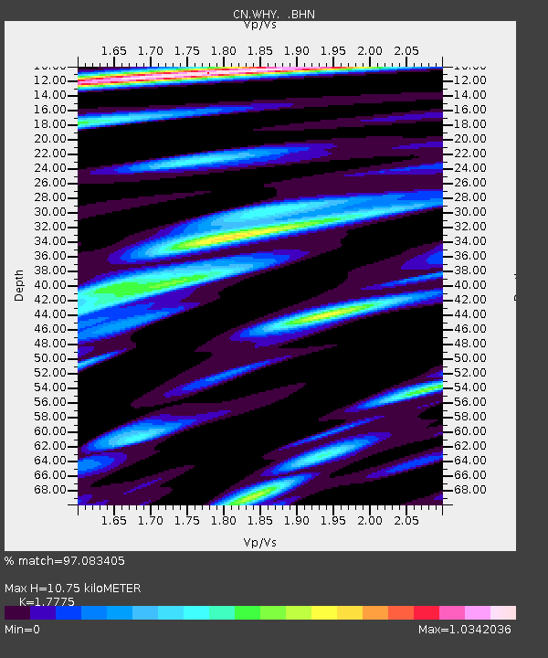
WHY Whitehorse, YT - Earthquake Result Viewer
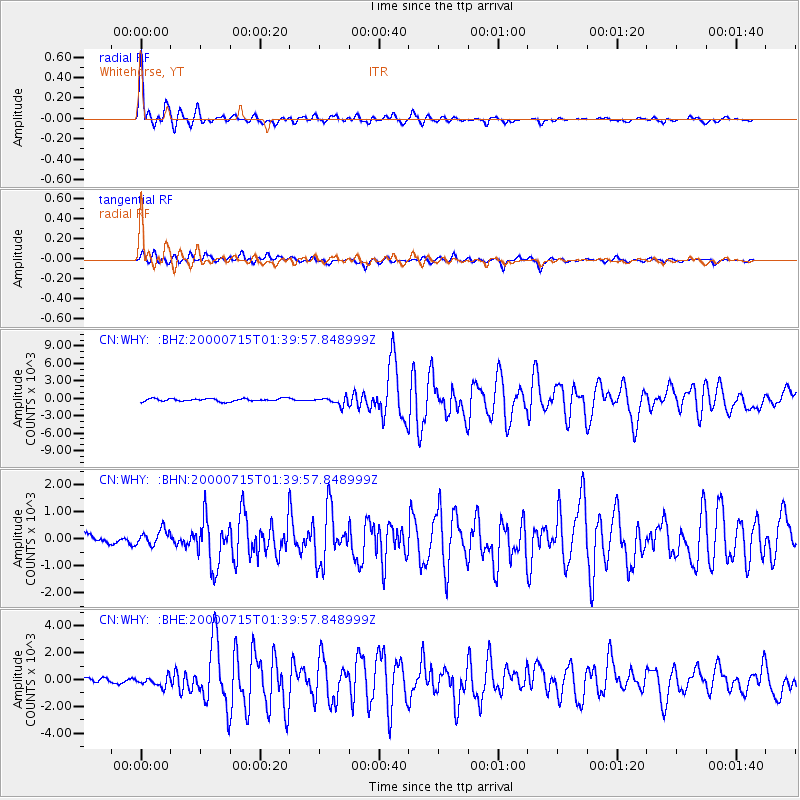
Earthquake location: Near S. Coast Of Honshu, Japan
Earthquake latitude/longitude: 34.3/139.3
Earthquake time(UTC): 2000/07/15 (197) 01:30:30 GMT
Earthquake Depth: 10 km
Earthquake Magnitude: 5.5 MB, 5.9 MS, 6.1 MW, 6.0 MW
Earthquake Catalog/Contributor: WHDF/NEIC
Network: CN Canadian National Seismograph Network
Station: WHY Whitehorse, YT
Lat/Lon: 60.66 N/134.88 W
Elevation: 1292 m
Distance: 58.8 deg
Az: 35.044 deg
Baz: 285.207 deg
Ray Param: 0.06260146
Estimated Moho Depth: 10.75 km
Estimated Crust Vp/Vs: 1.78
Assumed Crust Vp: 6.419 km/s
Estimated Crust Vs: 3.611 km/s
Estimated Crust Poisson's Ratio: 0.27
Radial Match: 97.083405 %
Radial Bump: 400
Transverse Match: 86.996445 %
Transverse Bump: 400
SOD ConfigId: 3744
Insert Time: 2010-02-27 07:40:42.179 +0000
GWidth: 2.5
Max Bumps: 400
Tol: 0.001

Signal To Noise

ChannelStoNSTALTA
CN:WHY: :BHN:20000715T01:39:57.848999Z1.3519342299.4779221.5181
CN:WHY: :BHE:20000715T01:39:57.848999Z2.1239185356.1769167.69801
CN:WHY: :BHZ:20000715T01:39:57.848999Z2.7163737664.99115244.80841
Arrivals
Ps1.4 SECOND
PpPs4.4 SECOND
PsPs/PpSs5.8 SECOND