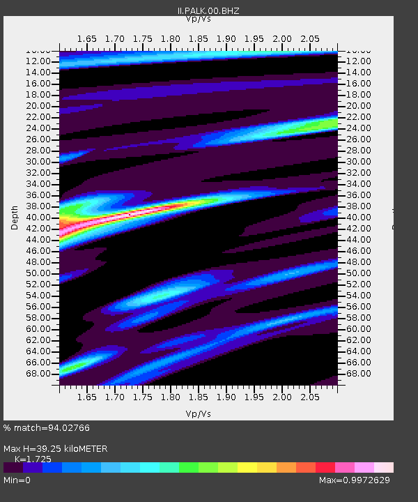
PALK Pallekele, Sri Lanka - Earthquake Result Viewer
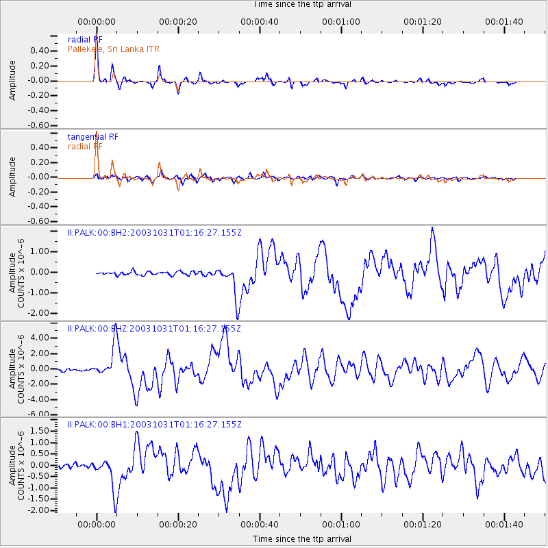
Earthquake location: Off East Coast Of Honshu, Japan
Earthquake latitude/longitude: 37.8/142.6
Earthquake time(UTC): 2003/10/31 (304) 01:06:28 GMT
Earthquake Depth: 10 km
Earthquake Magnitude: 6.1 MB, 6.8 MS, 7.0 MW, 7.0 MW
Earthquake Catalog/Contributor: WHDF/NEIC
Network: II Global Seismograph Network (GSN - IRIS/IDA)
Station: PALK Pallekele, Sri Lanka
Lat/Lon: 7.27 N/80.70 E
Elevation: 460 m
Distance: 63.5 deg
Az: 258.033 deg
Baz: 51.353 deg
Ray Param: 0.059556022
Estimated Moho Depth: 39.25 km
Estimated Crust Vp/Vs: 1.73
Assumed Crust Vp: 6.545 km/s
Estimated Crust Vs: 3.794 km/s
Estimated Crust Poisson's Ratio: 0.25
Radial Match: 94.02766 %
Radial Bump: 241
Transverse Match: 82.92944 %
Transverse Bump: 400
SOD ConfigId: 590571
Insert Time: 2013-09-25 03:49:07.338 +0000
GWidth: 2.5
Max Bumps: 400
Tol: 0.001

Signal To Noise

ChannelStoNSTALTA
II:PALK:00:BHZ:20031031T01:16:27.155Z18.5839862.131099E-61.1467396E-7
II:PALK:00:BH1:20031031T01:16:27.155Z9.3761047.466407E-77.9632294E-8
II:PALK:00:BH2:20031031T01:16:27.155Z9.9705867.9154825E-77.9388336E-8
Arrivals
Ps4.6 SECOND
PpPs16 SECOND
PsPs/PpSs20 SECOND