You are here: Home > Network List > IU - Global Seismograph Network (GSN - IRIS/USGS) Stations List
> Station RSSD Black Hills, South Dakota, USA > Earthquake Result Viewer
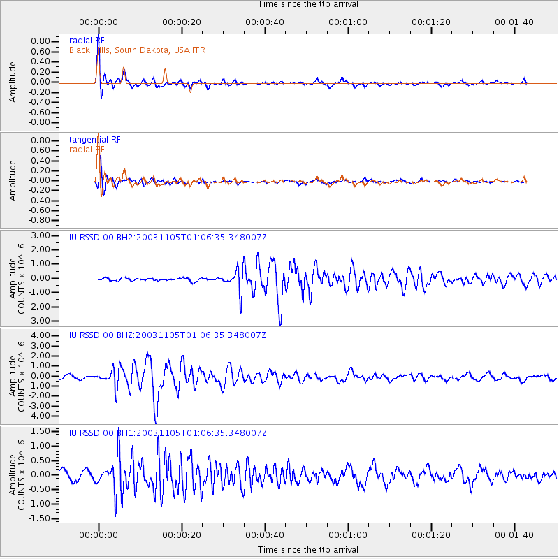
RSSD Black Hills, South Dakota, USA - Earthquake Result Viewer
*The percent match for this event was below the threshold and hence no stack was calculated.
| Earthquake location: |
Near West Coast Of Colombia |
| Earthquake latitude/longitude: |
5.0/-77.8 |
| Earthquake time(UTC): |
2003/11/05 (309) 00:58:51 GMT |
| Earthquake Depth: |
33 km |
| Earthquake Magnitude: |
5.7 MB, 5.4 MS, 6.0 MW, 5.9 MW |
| Earthquake Catalog/Contributor: |
WHDF/NEIC |
|
| Network: |
IU Global Seismograph Network (GSN - IRIS/USGS) |
| Station: |
RSSD Black Hills, South Dakota, USA |
| Lat/Lon: |
44.12 N/104.04 W |
| Elevation: |
2060 m |
|
| Distance: |
45.3 deg |
| Az: |
333.367 deg |
| Baz: |
141.676 deg |
| Ray Param: |
$rayparam |
*The percent match for this event was below the threshold and hence was not used in the summary stack. |
|
| Radial Match: |
89.123116 % |
| Radial Bump: |
303 |
| Transverse Match: |
83.38141 % |
| Transverse Bump: |
400 |
| SOD ConfigId: |
590571 |
| Insert Time: |
2013-09-25 03:51:44.718 +0000 |
| GWidth: |
2.5 |
| Max Bumps: |
400 |
| Tol: |
0.001 |
|
Signal To Noise
| Channel | StoN | STA | LTA |
| IU:RSSD:00:BHZ:20031105T01:06:35.348007Z | 5.4820766 | 7.997961E-7 | 1.4589291E-7 |
| IU:RSSD:00:BH1:20031105T01:06:35.348007Z | 4.180573 | 5.395083E-7 | 1.2905127E-7 |
| IU:RSSD:00:BH2:20031105T01:06:35.348007Z | 7.372599 | 7.222426E-7 | 9.796309E-8 |
| Arrivals |
| Ps | |
| PpPs | |
| PsPs/PpSs | |


