You are here: Home > Network List > IU - Global Seismograph Network (GSN - IRIS/USGS) Stations List
> Station TATO Taipei, Taiwan > Earthquake Result Viewer
TATO Taipei, Taiwan - Earthquake Result Viewer
| Earthquake location: |
Vanuatu Islands |
| Earthquake latitude/longitude: |
-19.3/168.9 |
| Earthquake time(UTC): |
2003/11/06 (310) 10:38:04 GMT |
| Earthquake Depth: |
114 km |
| Earthquake Magnitude: |
6.0 MB, 6.6 MW, 6.6 MW |
| Earthquake Catalog/Contributor: |
WHDF/NEIC |
|
| Network: |
IU Global Seismograph Network (GSN - IRIS/USGS) |
| Station: |
TATO Taipei, Taiwan |
| Lat/Lon: |
24.98 N/121.49 E |
| Elevation: |
53 m |
|
| Distance: |
63.7 deg |
| Az: |
311.836 deg |
| Baz: |
129.146 deg |
| Ray Param: |
0.05906774 |
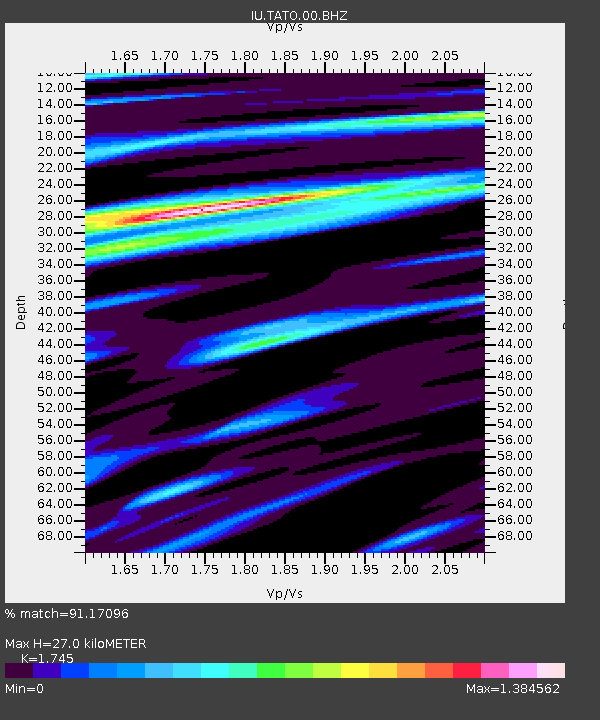
| Estimated Moho Depth: |
27.0 km |
| Estimated Crust Vp/Vs: |
1.75 |
| Assumed Crust Vp: |
6.289 km/s |
| Estimated Crust Vs: |
3.604 km/s |
| Estimated Crust Poisson's Ratio: |
0.26 |
|
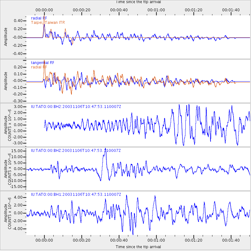
| Radial Match: |
91.17096 % |
| Radial Bump: |
400 |
| Transverse Match: |
86.11295 % |
| Transverse Bump: |
400 |
| SOD ConfigId: |
590571 |
| Insert Time: |
2013-09-25 03:52:36.842 +0000 |
| GWidth: |
2.5 |
| Max Bumps: |
400 |
| Tol: |
0.001 |
|
Signal To Noise
| Channel | StoN | STA | LTA |
| IU:TATO:00:BHZ:20031106T10:47:53.110007Z | 2.5346348 | 1.4070547E-6 | 5.551311E-7 |
| IU:TATO:00:BH1:20031106T10:47:53.110007Z | 1.4514956 | 7.5535826E-7 | 5.2039996E-7 |
| IU:TATO:00:BH2:20031106T10:47:53.110007Z | 1.3840026 | 5.5168255E-7 | 3.9861385E-7 |
| Arrivals |
| Ps | 3.3 SECOND |
| PpPs | 11 SECOND |
| PsPs/PpSs | 15 SECOND |


