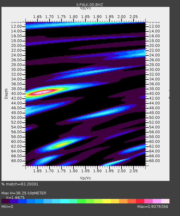
PALK Pallekele, Sri Lanka - Earthquake Result Viewer
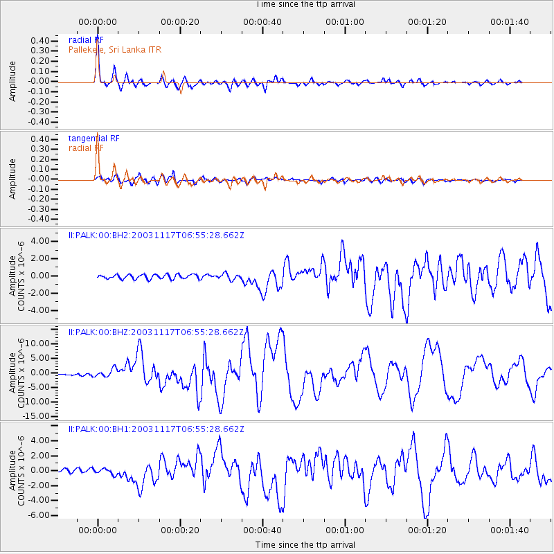
Earthquake location: Rat Islands, Aleutian Islands
Earthquake latitude/longitude: 51.1/178.6
Earthquake time(UTC): 2003/11/17 (321) 06:43:06 GMT
Earthquake Depth: 33 km
Earthquake Magnitude: 6.2 MB, 7.2 MS, 7.8 MW, 7.7 MW
Earthquake Catalog/Contributor: WHDF/NEIC
Network: II Global Seismograph Network (GSN - IRIS/IDA)
Station: PALK Pallekele, Sri Lanka
Lat/Lon: 7.27 N/80.70 E
Elevation: 460 m
Distance: 89.4 deg
Az: 280.706 deg
Baz: 38.6 deg
Ray Param: 0.04187037
Estimated Moho Depth: 39.25 km
Estimated Crust Vp/Vs: 1.67
Assumed Crust Vp: 6.545 km/s
Estimated Crust Vs: 3.925 km/s
Estimated Crust Poisson's Ratio: 0.22
Radial Match: 93.28081 %
Radial Bump: 400
Transverse Match: 89.97343 %
Transverse Bump: 400
SOD ConfigId: 590571
Insert Time: 2013-09-25 03:59:57.718 +0000
GWidth: 2.5
Max Bumps: 400
Tol: 0.001

Signal To Noise

ChannelStoNSTALTA
II:PALK:00:BHZ:20031117T06:55:28.662Z4.53886371.4127429E-63.1125475E-7
II:PALK:00:BH1:20031117T06:55:28.662Z1.3022063.8594513E-72.9637795E-7
II:PALK:00:BH2:20031117T06:55:28.662Z1.38535253.3792085E-72.439241E-7
Arrivals
Ps4.1 SECOND
PpPs16 SECOND
PsPs/PpSs20 SECOND