You are here: Home > Network List > IU - Global Seismograph Network (GSN - IRIS/USGS) Stations List
> Station RSSD Black Hills, South Dakota, USA > Earthquake Result Viewer
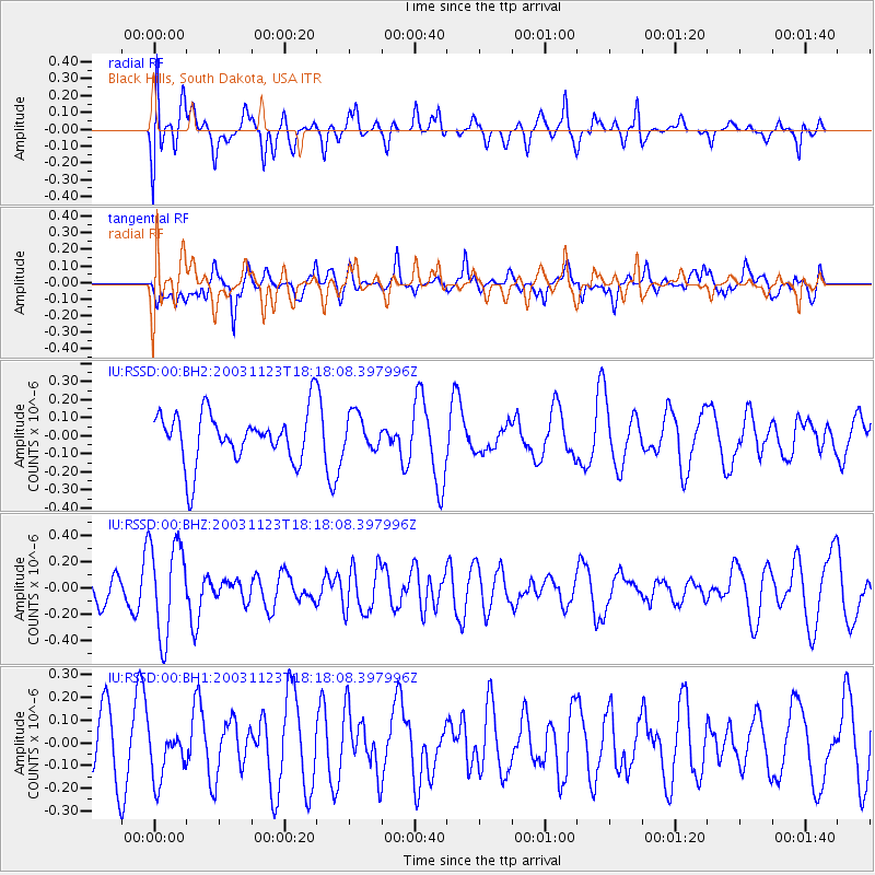
RSSD Black Hills, South Dakota, USA - Earthquake Result Viewer
*The percent match for this event was below the threshold and hence no stack was calculated.
| Earthquake location: |
Tonga Islands |
| Earthquake latitude/longitude: |
-15.9/-173.9 |
| Earthquake time(UTC): |
2003/11/23 (327) 18:06:04 GMT |
| Earthquake Depth: |
98 km |
| Earthquake Magnitude: |
5.7 MW, 5.7 MW |
| Earthquake Catalog/Contributor: |
NEIC PDE/NEIC PDE-M |
|
| Network: |
IU Global Seismograph Network (GSN - IRIS/USGS) |
| Station: |
RSSD Black Hills, South Dakota, USA |
| Lat/Lon: |
44.12 N/104.04 W |
| Elevation: |
2060 m |
|
| Distance: |
87.1 deg |
| Az: |
42.597 deg |
| Baz: |
244.736 deg |
| Ray Param: |
$rayparam |
*The percent match for this event was below the threshold and hence was not used in the summary stack. |
|
| Radial Match: |
57.841724 % |
| Radial Bump: |
400 |
| Transverse Match: |
55.99901 % |
| Transverse Bump: |
400 |
| SOD ConfigId: |
590571 |
| Insert Time: |
2013-09-25 04:03:36.716 +0000 |
| GWidth: |
2.5 |
| Max Bumps: |
400 |
| Tol: |
0.001 |
|
Signal To Noise
| Channel | StoN | STA | LTA |
| IU:RSSD:00:BHZ:20031123T18:18:08.397996Z | 4.2251973 | 3.5593774E-7 | 8.4241684E-8 |
| IU:RSSD:00:BH1:20031123T18:18:08.397996Z | 0.8171838 | 1.1329516E-7 | 1.3864097E-7 |
| IU:RSSD:00:BH2:20031123T18:18:08.397996Z | 0.6981428 | 9.82402E-8 | 1.4071648E-7 |
| Arrivals |
| Ps | |
| PpPs | |
| PsPs/PpSs | |


