You are here: Home > Network List > IU - Global Seismograph Network (GSN - IRIS/USGS) Stations List
> Station RSSD Black Hills, South Dakota, USA > Earthquake Result Viewer
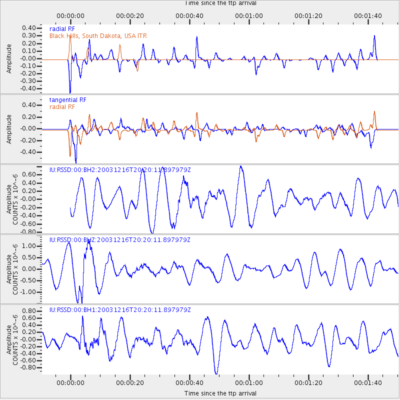
RSSD Black Hills, South Dakota, USA - Earthquake Result Viewer
*The percent match for this event was below the threshold and hence no stack was calculated.
| Earthquake location: |
Fiji Islands Region |
| Earthquake latitude/longitude: |
-18.9/-177.3 |
| Earthquake time(UTC): |
2003/12/16 (350) 20:08:18 GMT |
| Earthquake Depth: |
382 km |
| Earthquake Magnitude: |
5.6 MW, 5.7 MW |
| Earthquake Catalog/Contributor: |
NEIC PDE/NEIC PDE-M |
|
| Network: |
IU Global Seismograph Network (GSN - IRIS/USGS) |
| Station: |
RSSD Black Hills, South Dakota, USA |
| Lat/Lon: |
44.12 N/104.04 W |
| Elevation: |
2060 m |
|
| Distance: |
91.6 deg |
| Az: |
43.639 deg |
| Baz: |
245.116 deg |
| Ray Param: |
$rayparam |
*The percent match for this event was below the threshold and hence was not used in the summary stack. |
|
| Radial Match: |
63.889427 % |
| Radial Bump: |
400 |
| Transverse Match: |
76.95126 % |
| Transverse Bump: |
400 |
| SOD ConfigId: |
590571 |
| Insert Time: |
2013-09-25 04:13:49.014 +0000 |
| GWidth: |
2.5 |
| Max Bumps: |
400 |
| Tol: |
0.001 |
|
Signal To Noise
| Channel | StoN | STA | LTA |
| IU:RSSD:00:BHZ:20031216T20:20:11.897979Z | 2.315543 | 9.704875E-7 | 4.1911875E-7 |
| IU:RSSD:00:BH1:20031216T20:20:11.897979Z | 0.64518106 | 2.0883878E-7 | 3.2369022E-7 |
| IU:RSSD:00:BH2:20031216T20:20:11.897979Z | 1.5532037 | 5.326857E-7 | 3.429593E-7 |
| Arrivals |
| Ps | |
| PpPs | |
| PsPs/PpSs | |


