You are here: Home > Network List > II - Global Seismograph Network (GSN - IRIS/IDA) Stations List
> Station PALK Pallekele, Sri Lanka > Earthquake Result Viewer
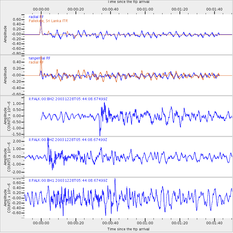
PALK Pallekele, Sri Lanka - Earthquake Result Viewer
*The percent match for this event was below the threshold and hence no stack was calculated.
| Earthquake location: |
Minahassa Peninsula, Sulawesi |
| Earthquake latitude/longitude: |
0.6/122.3 |
| Earthquake time(UTC): |
2003/12/28 (362) 05:36:54 GMT |
| Earthquake Depth: |
75 km |
| Earthquake Magnitude: |
5.9 MW, 5.9 MW |
| Earthquake Catalog/Contributor: |
NEIC PDE/NEIC PDE-M |
|
| Network: |
II Global Seismograph Network (GSN - IRIS/IDA) |
| Station: |
PALK Pallekele, Sri Lanka |
| Lat/Lon: |
7.27 N/80.70 E |
| Elevation: |
460 m |
|
| Distance: |
42.0 deg |
| Az: |
280.152 deg |
| Baz: |
97.176 deg |
| Ray Param: |
$rayparam |
*The percent match for this event was below the threshold and hence was not used in the summary stack. |
|
| Radial Match: |
64.786316 % |
| Radial Bump: |
400 |
| Transverse Match: |
54.900406 % |
| Transverse Bump: |
400 |
| SOD ConfigId: |
590571 |
| Insert Time: |
2013-09-25 04:23:49.518 +0000 |
| GWidth: |
2.5 |
| Max Bumps: |
400 |
| Tol: |
0.001 |
|
Signal To Noise
| Channel | StoN | STA | LTA |
| II:PALK:00:BHZ:20031228T05:44:08.67499Z | 4.10233 | 7.038116E-7 | 1.7156387E-7 |
| II:PALK:00:BH1:20031228T05:44:08.67499Z | 1.2877117 | 2.1628016E-7 | 1.6795697E-7 |
| II:PALK:00:BH2:20031228T05:44:08.67499Z | 2.7038147 | 4.9999215E-7 | 1.84921E-7 |
| Arrivals |
| Ps | |
| PpPs | |
| PsPs/PpSs | |


