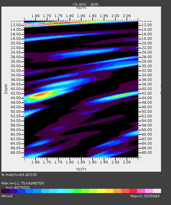
WHY Whitehorse, YT - Earthquake Result Viewer
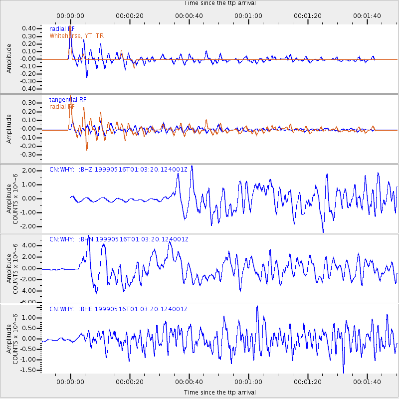
Earthquake location: New Britain Region, P.N.G.
Earthquake latitude/longitude: -4.8/152.5
Earthquake time(UTC): 1999/05/16 (136) 00:51:20 GMT
Earthquake Depth: 74 km
Earthquake Magnitude: 6.0 MB, 7.0 MS, 7.1 MW, 6.3 ME
Earthquake Catalog/Contributor: WHDF/NEIC
Network: CN Canadian National Seismograph Network
Station: WHY Whitehorse, YT
Lat/Lon: 60.66 N/134.88 W
Elevation: 1292 m
Distance: 85.7 deg
Az: 28.123 deg
Baz: 252.527 deg
Ray Param: 0.044429943
Estimated Moho Depth: 11.75 km
Estimated Crust Vp/Vs: 1.61
Assumed Crust Vp: 6.419 km/s
Estimated Crust Vs: 3.993 km/s
Estimated Crust Poisson's Ratio: 0.18
Radial Match: 94.60335 %
Radial Bump: 400
Transverse Match: 84.087814 %
Transverse Bump: 400
SOD ConfigId: 4480
Insert Time: 2010-02-27 07:42:06.017 +0000
GWidth: 2.5
Max Bumps: 400
Tol: 0.001

Signal To Noise

ChannelStoNSTALTA
CN:WHY: :BHN:19990516T01:03:20.124001Z10.7253998.423914E-77.854173E-8
CN:WHY: :BHE:19990516T01:03:20.124001Z1.97768841.3824612E-76.990288E-8
CN:WHY: :BHZ:19990516T01:03:20.124001Z1.99880662.186683E-71.0939944E-7
Arrivals
Ps1.1 SECOND
PpPs4.7 SECOND
PsPs/PpSs5.8 SECOND