You are here: Home > Network List > IU - Global Seismograph Network (GSN - IRIS/USGS) Stations List
> Station POHA Pohakuloa, Hawaii, USA > Earthquake Result Viewer
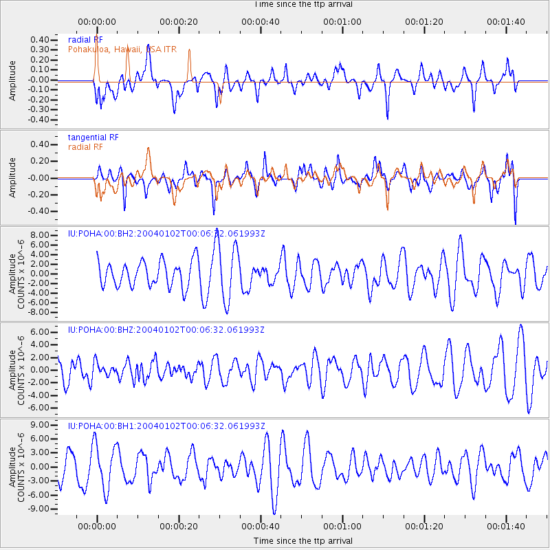
POHA Pohakuloa, Hawaii, USA - Earthquake Result Viewer
*The percent match for this event was below the threshold and hence no stack was calculated.
| Earthquake location: |
Near Coast Of Guerrero, Mexico |
| Earthquake latitude/longitude: |
17.4/-101.3 |
| Earthquake time(UTC): |
2004/01/01 (001) 23:58:01 GMT |
| Earthquake Depth: |
28 km |
| Earthquake Magnitude: |
5.8 MS, 5.7 MW |
| Earthquake Catalog/Contributor: |
NEIC PDE/NEIC PDE-M |
|
| Network: |
IU Global Seismograph Network (GSN - IRIS/USGS) |
| Station: |
POHA Pohakuloa, Hawaii, USA |
| Lat/Lon: |
19.76 N/155.53 W |
| Elevation: |
1967 m |
|
| Distance: |
51.3 deg |
| Az: |
281.608 deg |
| Baz: |
83.177 deg |
| Ray Param: |
$rayparam |
*The percent match for this event was below the threshold and hence was not used in the summary stack. |
|
| Radial Match: |
48.54643 % |
| Radial Bump: |
400 |
| Transverse Match: |
50.523823 % |
| Transverse Bump: |
400 |
| SOD ConfigId: |
590571 |
| Insert Time: |
2013-09-25 04:28:09.907 +0000 |
| GWidth: |
2.5 |
| Max Bumps: |
400 |
| Tol: |
0.001 |
|
Signal To Noise
| Channel | StoN | STA | LTA |
| IU:POHA:00:BHZ:20040102T00:06:32.061993Z | 0.48967174 | 1.0267709E-6 | 2.0968555E-6 |
| IU:POHA:00:BH1:20040102T00:06:32.061993Z | 1.8453858 | 4.8876072E-6 | 2.648556E-6 |
| IU:POHA:00:BH2:20040102T00:06:32.061993Z | 2.3518121 | 6.072191E-6 | 2.58192E-6 |
| Arrivals |
| Ps | |
| PpPs | |
| PsPs/PpSs | |


