You are here: Home > Network List > IU - Global Seismograph Network (GSN - IRIS/USGS) Stations List
> Station MBWA Marble Bar, Western Australia > Earthquake Result Viewer
MBWA Marble Bar, Western Australia - Earthquake Result Viewer
| Earthquake location: |
South Indian Ocean |
| Earthquake latitude/longitude: |
-36.7/53.4 |
| Earthquake time(UTC): |
2004/01/11 (011) 04:32:47 GMT |
| Earthquake Depth: |
5.3 km |
| Earthquake Magnitude: |
6.1 MB, 6.1 MS, 6.2 MW, 6.2 MW |
| Earthquake Catalog/Contributor: |
WHDF/NEIC |
|
| Network: |
IU Global Seismograph Network (GSN - IRIS/USGS) |
| Station: |
MBWA Marble Bar, Western Australia |
| Lat/Lon: |
21.16 S/119.73 E |
| Elevation: |
190 m |
|
| Distance: |
59.1 deg |
| Az: |
94.407 deg |
| Baz: |
239.153 deg |
| Ray Param: |
0.06244786 |
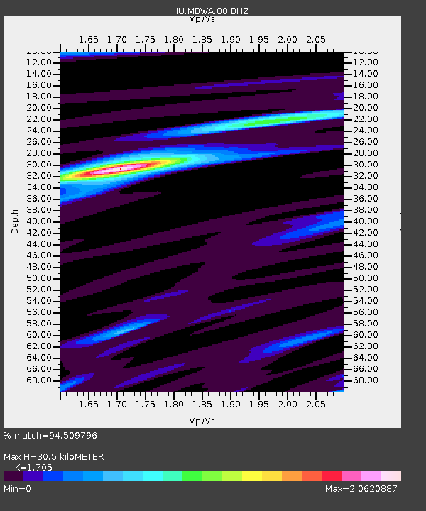
| Estimated Moho Depth: |
30.5 km |
| Estimated Crust Vp/Vs: |
1.71 |
| Assumed Crust Vp: |
6.464 km/s |
| Estimated Crust Vs: |
3.791 km/s |
| Estimated Crust Poisson's Ratio: |
0.24 |
|
| Radial Match: |
94.509796 % |
| Radial Bump: |
311 |
| Transverse Match: |
77.85234 % |
| Transverse Bump: |
400 |
| SOD ConfigId: |
590571 |
| Insert Time: |
2013-09-25 04:35:03.548 +0000 |
| GWidth: |
2.5 |
| Max Bumps: |
400 |
| Tol: |
0.001 |
|

Signal To Noise
| Channel | StoN | STA | LTA |
| IU:MBWA:00:BHZ:20040111T04:42:17.672996Z | 9.086785 | 1.7582462E-6 | 1.9349486E-7 |
| IU:MBWA:00:BH1:20040111T04:42:17.672996Z | 4.6644907 | 9.137418E-7 | 1.9589315E-7 |
| IU:MBWA:00:BH2:20040111T04:42:17.672996Z | 2.1516623 | 3.8186906E-7 | 1.774763E-7 |
| Arrivals |
| Ps | 3.5 SECOND |
| PpPs | 12 SECOND |
| PsPs/PpSs | 16 SECOND |


