You are here: Home > Network List > IU - Global Seismograph Network (GSN - IRIS/USGS) Stations List
> Station RSSD Black Hills, South Dakota, USA > Earthquake Result Viewer
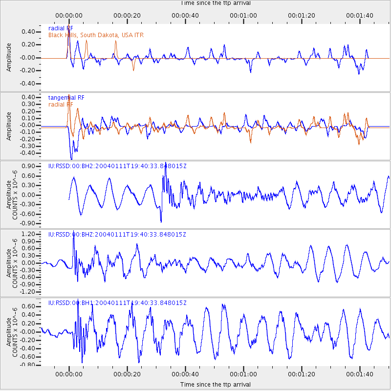
RSSD Black Hills, South Dakota, USA - Earthquake Result Viewer
*The percent match for this event was below the threshold and hence no stack was calculated.
| Earthquake location: |
Komandorskiye Ostrova Region |
| Earthquake latitude/longitude: |
55.6/165.7 |
| Earthquake time(UTC): |
2004/01/11 (011) 19:31:32 GMT |
| Earthquake Depth: |
21 km |
| Earthquake Magnitude: |
5.5 MW |
| Earthquake Catalog/Contributor: |
NEIC PDE/NEIC PDE-M |
|
| Network: |
IU Global Seismograph Network (GSN - IRIS/USGS) |
| Station: |
RSSD Black Hills, South Dakota, USA |
| Lat/Lon: |
44.12 N/104.04 W |
| Elevation: |
2060 m |
|
| Distance: |
55.3 deg |
| Az: |
61.15 deg |
| Baz: |
316.345 deg |
| Ray Param: |
$rayparam |
*The percent match for this event was below the threshold and hence was not used in the summary stack. |
|
| Radial Match: |
65.063225 % |
| Radial Bump: |
358 |
| Transverse Match: |
74.82659 % |
| Transverse Bump: |
400 |
| SOD ConfigId: |
590571 |
| Insert Time: |
2013-09-25 04:36:31.053 +0000 |
| GWidth: |
2.5 |
| Max Bumps: |
400 |
| Tol: |
0.001 |
|
Signal To Noise
| Channel | StoN | STA | LTA |
| IU:RSSD:00:BHZ:20040111T19:40:33.848015Z | 3.240794 | 3.9415565E-7 | 1.2162317E-7 |
| IU:RSSD:00:BH1:20040111T19:40:33.848015Z | 1.8189571 | 2.9524512E-7 | 1.623156E-7 |
| IU:RSSD:00:BH2:20040111T19:40:33.848015Z | 1.5383416 | 4.4987982E-7 | 2.9244467E-7 |
| Arrivals |
| Ps | |
| PpPs | |
| PsPs/PpSs | |


