You are here: Home > Network List > IU - Global Seismograph Network (GSN - IRIS/USGS) Stations List
> Station RSSD Black Hills, South Dakota, USA > Earthquake Result Viewer
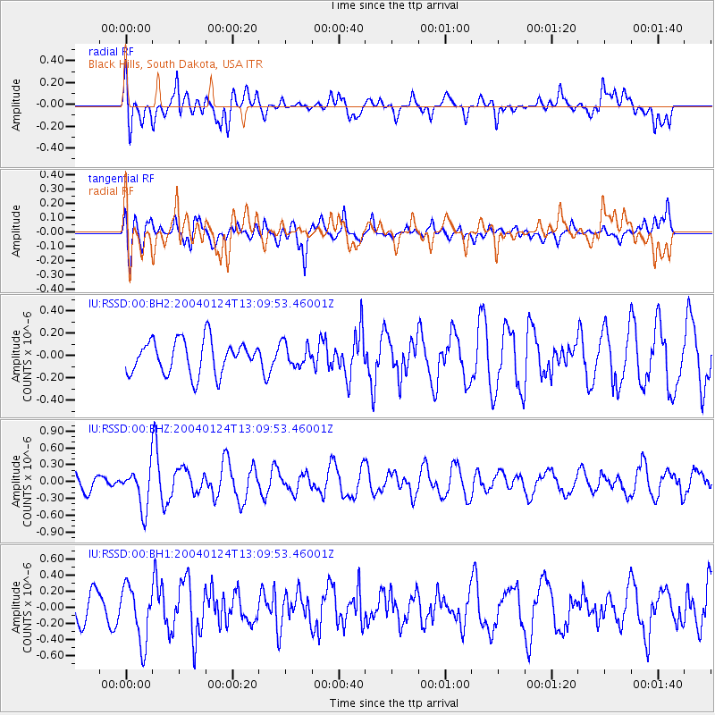
RSSD Black Hills, South Dakota, USA - Earthquake Result Viewer
*The percent match for this event was below the threshold and hence no stack was calculated.
| Earthquake location: |
Northern Mid-Atlantic Ridge |
| Earthquake latitude/longitude: |
52.1/-30.2 |
| Earthquake time(UTC): |
2004/01/24 (024) 13:01:45 GMT |
| Earthquake Depth: |
10 km |
| Earthquake Magnitude: |
5.6 MB, 5.4 MS, 5.9 MW, 5.8 MW |
| Earthquake Catalog/Contributor: |
WHDF/NEIC |
|
| Network: |
IU Global Seismograph Network (GSN - IRIS/USGS) |
| Station: |
RSSD Black Hills, South Dakota, USA |
| Lat/Lon: |
44.12 N/104.04 W |
| Elevation: |
2060 m |
|
| Distance: |
48.0 deg |
| Az: |
291.325 deg |
| Baz: |
52.888 deg |
| Ray Param: |
$rayparam |
*The percent match for this event was below the threshold and hence was not used in the summary stack. |
|
| Radial Match: |
50.54911 % |
| Radial Bump: |
400 |
| Transverse Match: |
56.014584 % |
| Transverse Bump: |
400 |
| SOD ConfigId: |
590571 |
| Insert Time: |
2013-09-25 04:42:33.496 +0000 |
| GWidth: |
2.5 |
| Max Bumps: |
400 |
| Tol: |
0.001 |
|
Signal To Noise
| Channel | StoN | STA | LTA |
| IU:RSSD:00:BHZ:20040124T13:09:53.46001Z | 2.0580356 | 3.6218316E-7 | 1.7598488E-7 |
| IU:RSSD:00:BH1:20040124T13:09:53.46001Z | 2.2290187 | 3.5343592E-7 | 1.5856122E-7 |
| IU:RSSD:00:BH2:20040124T13:09:53.46001Z | 0.67466867 | 1.0039203E-7 | 1.4880197E-7 |
| Arrivals |
| Ps | |
| PpPs | |
| PsPs/PpSs | |


