You are here: Home > Network List > IU - Global Seismograph Network (GSN - IRIS/USGS) Stations List
> Station POHA Pohakuloa, Hawaii, USA > Earthquake Result Viewer
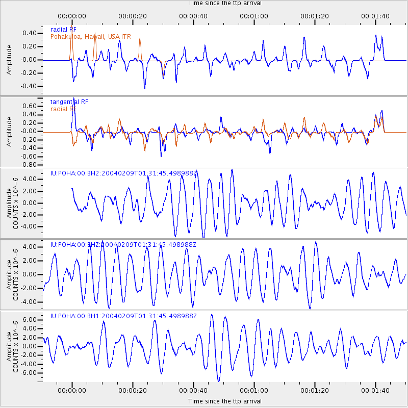
POHA Pohakuloa, Hawaii, USA - Earthquake Result Viewer
*The percent match for this event was below the threshold and hence no stack was calculated.
| Earthquake location: |
Baja California, Mexico |
| Earthquake latitude/longitude: |
24.9/-112.4 |
| Earthquake time(UTC): |
2004/02/09 (040) 01:24:40 GMT |
| Earthquake Depth: |
10 km |
| Earthquake Magnitude: |
5.5 MW |
| Earthquake Catalog/Contributor: |
NEIC PDE/NEIC PDE-M |
|
| Network: |
IU Global Seismograph Network (GSN - IRIS/USGS) |
| Station: |
POHA Pohakuloa, Hawaii, USA |
| Lat/Lon: |
19.76 N/155.53 W |
| Elevation: |
1967 m |
|
| Distance: |
40.1 deg |
| Az: |
271.551 deg |
| Baz: |
74.548 deg |
| Ray Param: |
$rayparam |
*The percent match for this event was below the threshold and hence was not used in the summary stack. |
|
| Radial Match: |
51.31007 % |
| Radial Bump: |
400 |
| Transverse Match: |
68.568214 % |
| Transverse Bump: |
400 |
| SOD ConfigId: |
590571 |
| Insert Time: |
2013-09-25 04:55:19.077 +0000 |
| GWidth: |
2.5 |
| Max Bumps: |
400 |
| Tol: |
0.001 |
|
Signal To Noise
| Channel | StoN | STA | LTA |
| IU:POHA:00:BHZ:20040209T01:31:45.498988Z | 1.1253319 | 1.9719753E-6 | 1.75235E-6 |
| IU:POHA:00:BH1:20040209T01:31:45.498988Z | 0.1566532 | 3.1405207E-7 | 2.00476E-6 |
| IU:POHA:00:BH2:20040209T01:31:45.498988Z | 1.8335577 | 2.8417076E-6 | 1.5498326E-6 |
| Arrivals |
| Ps | |
| PpPs | |
| PsPs/PpSs | |


