You are here: Home > Network List > IU - Global Seismograph Network (GSN - IRIS/USGS) Stations List
> Station RSSD Black Hills, South Dakota, USA > Earthquake Result Viewer
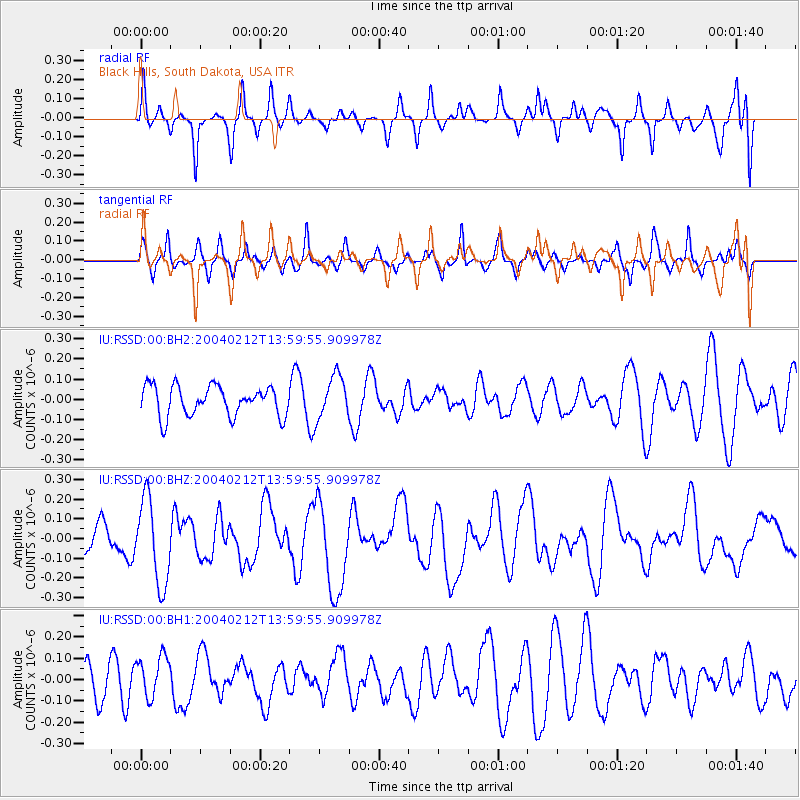
RSSD Black Hills, South Dakota, USA - Earthquake Result Viewer
*The percent match for this event was below the threshold and hence no stack was calculated.
| Earthquake location: |
Tonga Islands |
| Earthquake latitude/longitude: |
-19.2/-173.5 |
| Earthquake time(UTC): |
2004/02/12 (043) 13:47:32 GMT |
| Earthquake Depth: |
21 km |
| Earthquake Magnitude: |
5.8 MW, 5.7 MW, 5.8 MS |
| Earthquake Catalog/Contributor: |
NEIC PDE/NEIC PDE-M |
|
| Network: |
IU Global Seismograph Network (GSN - IRIS/USGS) |
| Station: |
RSSD Black Hills, South Dakota, USA |
| Lat/Lon: |
44.12 N/104.04 W |
| Elevation: |
2060 m |
|
| Distance: |
89.3 deg |
| Az: |
42.42 deg |
| Baz: |
242.255 deg |
| Ray Param: |
$rayparam |
*The percent match for this event was below the threshold and hence was not used in the summary stack. |
|
| Radial Match: |
53.72697 % |
| Radial Bump: |
368 |
| Transverse Match: |
42.969334 % |
| Transverse Bump: |
308 |
| SOD ConfigId: |
590571 |
| Insert Time: |
2013-09-25 04:57:10.454 +0000 |
| GWidth: |
2.5 |
| Max Bumps: |
400 |
| Tol: |
0.001 |
|
Signal To Noise
| Channel | StoN | STA | LTA |
| IU:RSSD:00:BHZ:20040212T13:59:55.909978Z | 1.8971039 | 2.1615698E-7 | 1.139405E-7 |
| IU:RSSD:00:BH1:20040212T13:59:55.909978Z | 0.8958857 | 9.792773E-8 | 1.0930829E-7 |
| IU:RSSD:00:BH2:20040212T13:59:55.909978Z | 1.4640259 | 1.0763022E-7 | 7.351661E-8 |
| Arrivals |
| Ps | |
| PpPs | |
| PsPs/PpSs | |


