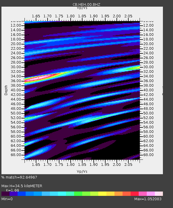
HEH Heihe,Heilongjiang Province - Earthquake Result Viewer
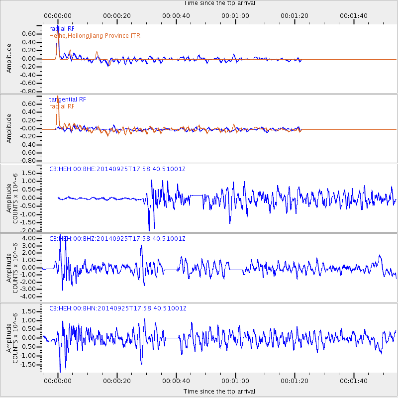
Earthquake location: Southern Alaska
Earthquake latitude/longitude: 62.0/-151.8
Earthquake time(UTC): 2014/09/25 (268) 17:51:17 GMT
Earthquake Depth: 103 km
Earthquake Magnitude: 6.2 ML, 6.1 MI, 6.2 MWW, 6.3 MWR, 6.3 MWB, 6.3 MWC
Earthquake Catalog/Contributor: NEIC PDE/NEIC COMCAT
Network: CB China National Seismic Network
Station: HEH Heihe,Heilongjiang Province
Lat/Lon: 50.25 N/127.41 E
Elevation: 165 m
Distance: 43.6 deg
Az: 293.232 deg
Baz: 42.579 deg
Ray Param: 0.07208838
Estimated Moho Depth: 34.5 km
Estimated Crust Vp/Vs: 1.66
Assumed Crust Vp: 6.419 km/s
Estimated Crust Vs: 3.867 km/s
Estimated Crust Poisson's Ratio: 0.22
Radial Match: 92.64967 %
Radial Bump: 342
Transverse Match: 76.815704 %
Transverse Bump: 400
SOD ConfigId: 3390531
Insert Time: 2019-04-14 05:30:28.197 +0000
GWidth: 2.5
Max Bumps: 400
Tol: 0.001

Signal To Noise

ChannelStoNSTALTA
CB:HEH:00:BHZ:20140925T17:58:40.51001Z23.8862821.6764336E-67.018395E-8
CB:HEH:00:BHN:20140925T17:58:40.51001Z8.4413086.801453E-78.057345E-8
CB:HEH:00:BHE:20140925T17:58:40.51001Z16.3829566.91629E-74.2216378E-8
Arrivals
Ps3.8 SECOND
PpPs13 SECOND
PsPs/PpSs17 SECOND