You are here: Home > Network List > IU - Global Seismograph Network (GSN - IRIS/USGS) Stations List
> Station RSSD Black Hills, South Dakota, USA > Earthquake Result Viewer
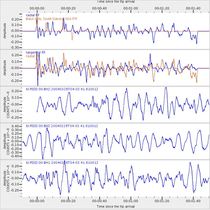
RSSD Black Hills, South Dakota, USA - Earthquake Result Viewer
*The percent match for this event was below the threshold and hence no stack was calculated.
| Earthquake location: |
Turkey |
| Earthquake latitude/longitude: |
39.8/40.9 |
| Earthquake time(UTC): |
2004/03/28 (088) 03:51:10 GMT |
| Earthquake Depth: |
5.0 km |
| Earthquake Magnitude: |
5.5 MW, 5.6 MW |
| Earthquake Catalog/Contributor: |
NEIC PDE/NEIC PDE-M |
|
| Network: |
IU Global Seismograph Network (GSN - IRIS/USGS) |
| Station: |
RSSD Black Hills, South Dakota, USA |
| Lat/Lon: |
44.12 N/104.04 W |
| Elevation: |
2060 m |
|
| Distance: |
90.6 deg |
| Az: |
335.541 deg |
| Baz: |
26.269 deg |
| Ray Param: |
$rayparam |
*The percent match for this event was below the threshold and hence was not used in the summary stack. |
|
| Radial Match: |
47.97085 % |
| Radial Bump: |
400 |
| Transverse Match: |
56.30301 % |
| Transverse Bump: |
400 |
| SOD ConfigId: |
590571 |
| Insert Time: |
2013-09-25 05:24:41.899 +0000 |
| GWidth: |
2.5 |
| Max Bumps: |
400 |
| Tol: |
0.001 |
|
Signal To Noise
| Channel | StoN | STA | LTA |
| IU:RSSD:00:BHZ:20040328T04:03:41.81001Z | 3.717468 | 2.4195427E-7 | 6.5085764E-8 |
| IU:RSSD:00:BH1:20040328T04:03:41.81001Z | 0.60246056 | 4.9009486E-8 | 8.134887E-8 |
| IU:RSSD:00:BH2:20040328T04:03:41.81001Z | 0.30630302 | 2.4937515E-8 | 8.141452E-8 |
| Arrivals |
| Ps | |
| PpPs | |
| PsPs/PpSs | |


