You are here: Home > Network List > IU - Global Seismograph Network (GSN - IRIS/USGS) Stations List
> Station RAR Rarotonga, Cook Islands > Earthquake Result Viewer
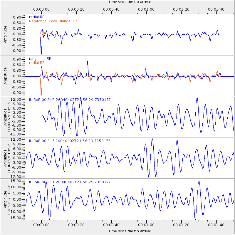
RAR Rarotonga, Cook Islands - Earthquake Result Viewer
*The percent match for this event was below the threshold and hence no stack was calculated.
| Earthquake location: |
Sunda Strait, Indonesia |
| Earthquake latitude/longitude: |
-6.0/104.1 |
| Earthquake time(UTC): |
2004/04/02 (093) 21:43:49 GMT |
| Earthquake Depth: |
42 km |
| Earthquake Magnitude: |
5.5 MW |
| Earthquake Catalog/Contributor: |
NEIC PDE/NEIC PDE-M |
|
| Network: |
IU Global Seismograph Network (GSN - IRIS/USGS) |
| Station: |
RAR Rarotonga, Cook Islands |
| Lat/Lon: |
21.21 S/159.77 W |
| Elevation: |
28 m |
|
| Distance: |
93.6 deg |
| Az: |
111.647 deg |
| Baz: |
262.199 deg |
| Ray Param: |
$rayparam |
*The percent match for this event was below the threshold and hence was not used in the summary stack. |
|
| Radial Match: |
51.02455 % |
| Radial Bump: |
391 |
| Transverse Match: |
66.019165 % |
| Transverse Bump: |
276 |
| SOD ConfigId: |
590571 |
| Insert Time: |
2013-09-25 05:26:14.340 +0000 |
| GWidth: |
2.5 |
| Max Bumps: |
400 |
| Tol: |
0.001 |
|
Signal To Noise
| Channel | StoN | STA | LTA |
| IU:RAR:00:BHZ:20040402T21:56:29.735017Z | 0.5119749 | 2.107956E-6 | 4.117304E-6 |
| IU:RAR:00:BH1:20040402T21:56:29.735017Z | 3.3656495 | 9.563116E-6 | 2.8413879E-6 |
| IU:RAR:00:BH2:20040402T21:56:29.735017Z | 0.42012212 | 2.889458E-6 | 6.8776626E-6 |
| Arrivals |
| Ps | |
| PpPs | |
| PsPs/PpSs | |


