You are here: Home > Network List > GS - US Geological Survey Networks Stations List
> Station KAN13 Rinehart Farm > Earthquake Result Viewer
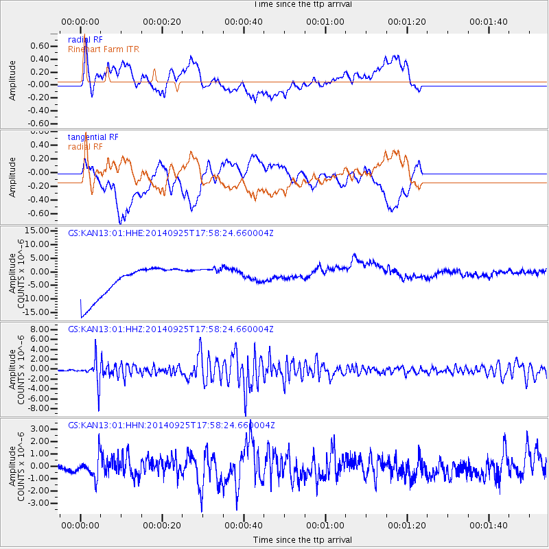
KAN13 Rinehart Farm - Earthquake Result Viewer
*The percent match for this event was below the threshold and hence no stack was calculated.
| Earthquake location: |
Southern Alaska |
| Earthquake latitude/longitude: |
62.0/-151.8 |
| Earthquake time(UTC): |
2014/09/25 (268) 17:51:17 GMT |
| Earthquake Depth: |
103 km |
| Earthquake Magnitude: |
6.2 ML, 6.1 MI, 6.2 MWW, 6.3 MWR, 6.3 MWB, 6.3 MWC |
| Earthquake Catalog/Contributor: |
NEIC PDE/NEIC COMCAT |
|
| Network: |
GS US Geological Survey Networks |
| Station: |
KAN13 Rinehart Farm |
| Lat/Lon: |
37.01 N/97.48 W |
| Elevation: |
340 m |
|
| Distance: |
41.5 deg |
| Az: |
101.158 deg |
| Baz: |
324.596 deg |
| Ray Param: |
$rayparam |
*The percent match for this event was below the threshold and hence was not used in the summary stack. |
|
| Radial Match: |
33.66698 % |
| Radial Bump: |
400 |
| Transverse Match: |
20.627813 % |
| Transverse Bump: |
400 |
| SOD ConfigId: |
3390531 |
| Insert Time: |
2019-04-14 05:31:55.264 +0000 |
| GWidth: |
2.5 |
| Max Bumps: |
400 |
| Tol: |
0.001 |
|
Signal To Noise
| Channel | StoN | STA | LTA |
| GS:KAN13:01:HHZ:20140925T17:58:24.660004Z | 15.097283 | 2.3560701E-6 | 1.5605922E-7 |
| GS:KAN13:01:HHN:20140925T17:58:24.660004Z | 1.7889357 | 8.460846E-7 | 4.7295418E-7 |
| GS:KAN13:01:HHE:20140925T17:58:24.660004Z | 0.8085576 | 4.6655878E-6 | 5.77026E-6 |
| Arrivals |
| Ps | |
| PpPs | |
| PsPs/PpSs | |


