You are here: Home > Network List > IU - Global Seismograph Network (GSN - IRIS/USGS) Stations List
> Station POHA Pohakuloa, Hawaii, USA > Earthquake Result Viewer
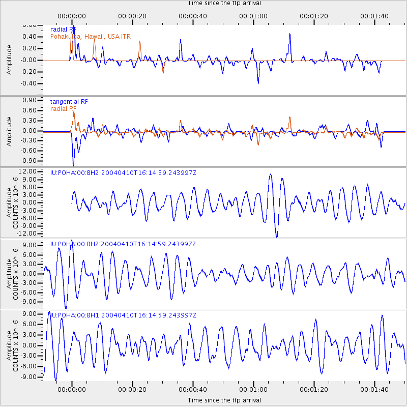
POHA Pohakuloa, Hawaii, USA - Earthquake Result Viewer
*The percent match for this event was below the threshold and hence no stack was calculated.
| Earthquake location: |
South Of Fiji Islands |
| Earthquake latitude/longitude: |
-24.7/-176.2 |
| Earthquake time(UTC): |
2004/04/10 (101) 16:06:47 GMT |
| Earthquake Depth: |
15 km |
| Earthquake Magnitude: |
5.5 MS, 5.7 MW |
| Earthquake Catalog/Contributor: |
NEIC PDE/NEIC PDE-M |
|
| Network: |
IU Global Seismograph Network (GSN - IRIS/USGS) |
| Station: |
POHA Pohakuloa, Hawaii, USA |
| Lat/Lon: |
19.76 N/155.53 W |
| Elevation: |
1967 m |
|
| Distance: |
48.5 deg |
| Az: |
26.306 deg |
| Baz: |
205.345 deg |
| Ray Param: |
$rayparam |
*The percent match for this event was below the threshold and hence was not used in the summary stack. |
|
| Radial Match: |
77.28825 % |
| Radial Bump: |
400 |
| Transverse Match: |
62.019093 % |
| Transverse Bump: |
400 |
| SOD ConfigId: |
590571 |
| Insert Time: |
2013-09-25 05:32:46.035 +0000 |
| GWidth: |
2.5 |
| Max Bumps: |
400 |
| Tol: |
0.001 |
|
Signal To Noise
| Channel | StoN | STA | LTA |
| IU:POHA:00:BHZ:20040410T16:14:59.243997Z | 1.946182 | 5.6658837E-6 | 2.9112814E-6 |
| IU:POHA:00:BH1:20040410T16:14:59.243997Z | 0.5978869 | 2.772848E-6 | 4.6377463E-6 |
| IU:POHA:00:BH2:20040410T16:14:59.243997Z | 1.2146286 | 3.185134E-6 | 2.622311E-6 |
| Arrivals |
| Ps | |
| PpPs | |
| PsPs/PpSs | |


